
Carte topographique Dedham
Carte interactive
Cliquez sur la carte pour afficher l’altitude.
À propos de cette carte
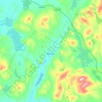
Nom : Carte topographique Dedham, altitude, relief.
Lieu : Dedham, Hancock County, Maine, 04429, United States (44.63872 -68.69093 44.75218 -68.50292)
Altitude moyenne : 112 m
Altitude minimum : 14 m
Altitude maximum : 374 m
Two McDonnell F-101 Voodoo fighters of the 75th Fighter Squadron were scrambled from Dow Air Force Base on the night of 11 April 1961 to intercept an unidentified aircraft approaching the United States. SAGE identified the incoming aircraft as a Strategic Air Command bomber shortly after the fighters were airborne. The fighters' return to Dow was complicated by a light spring rainstorm, creating an icy runway under a 500-foot cloud ceiling. Dow's tactical air navigation system glide slope function was temporarily disabled after the first aircraft landed. The second aircraft was cleared to descend to 2,200 feet, using a two-dimensional radar approach, when it hit Bald Mountain at an elevation of 1,200 feet. Both crewmen in the second aircraft were killed. Investigators concluded the airfield elevation had been incorrectly set on the aircraft altimeter, creating a 1000-foot error unrecognized when aircrew acknowledged only the last two digits of altimeter readings in radio transmissions.
Autres cartes topographiques
Cliquez sur une carte pour visualiser sa topographie, son altitude et son relief.
Battle Island
United States > Maine > Hancock County > Penobscot
Battle Island, Penobscot, Hancock County, Maine, 04476, United States
Altitude moyenne : 53 m
Upper Chain Lake
United States > Maine > Hancock County
Upper Chain Lake, Hancock County, Maine, United States
Altitude moyenne : 110 m
Bar Harbor
United States > Maine > Hancock County
Bar Harbor, Hancock County, Maine, 04609, United States
Altitude moyenne : 33 m
Ellsworth
United States > Maine > Hancock County
Ellsworth, Hancock County, Maine, United States
Altitude moyenne : 53 m
Ship Island
United States > Maine > Hancock County > Tremont
Ship Island, Tremont, Hancock County, Maine, United States
Altitude moyenne : 0 m
Deer Isle
United States > Maine > Hancock County > Deer Isle
Deer Isle, Hancock County, Maine, United States
Altitude moyenne : 10 m