
Carte topographique Edgewood
Carte interactive
Cliquez sur la carte pour afficher l’altitude.
À propos de cette carte
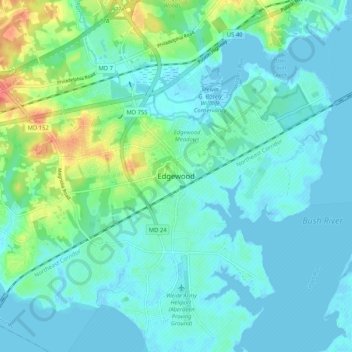
Nom : Carte topographique Edgewood, altitude, relief.
Lieu : Edgewood, Harford County, Maryland, 21040, United States (39.37872 -76.33440 39.45872 -76.25440)
Altitude moyenne : 12 m
Altitude minimum : -4 m
Altitude maximum : 61 m
Autres cartes topographiques
Cliquez sur une carte pour visualiser sa topographie, son altitude et son relief.
Bel Air
United States > Maryland > Harford County
Bel Air, Harford County, Maryland, 21014, United States
Altitude moyenne : 103 m
Highfield Park
United States > Maryland > Harford County > Bel Air
Highfield Park, Bel Air, Harford County, Maryland, United States
Altitude moyenne : 153 m
Havre de Grace
United States > Maryland > Harford County
Havre de Grace, Harford County, Maryland, 21078, United States
Altitude moyenne : 24 m
Wales of Harford
United States > Maryland > Harford County
Wales of Harford, Harford County, Maryland, 21047, United States
Altitude moyenne : 138 m
Aberdeen
United States > Maryland > Harford County > Aberdeen
Aberdeen, Harford County, Maryland, 21001-1734, United States
Altitude moyenne : 36 m
Meadow Springs
United States > Maryland > Harford County > Meadow Springs
Meadow Springs, Harford County, Maryland, 21028, United States
Altitude moyenne : 108 m