
Carte topographique Menzingen
Carte interactive
Cliquez sur la carte pour afficher l’altitude.
À propos de cette carte
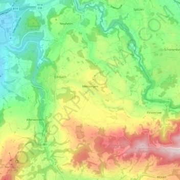
Nom : Carte topographique Menzingen, altitude, relief.
Lieu : Menzingen, Zug, 6313, Switzerland (47.14806 8.55440 47.20524 8.66577)
Altitude moyenne : 740 m
Altitude minimum : 443 m
Altitude maximum : 1.195 m
The municipality is located on a moraine plateau between the Lorze and Sihl rivers at an elevation of about 800 m (2,600 ft). In 1848 the municipality of Neuheim separated from Menzingen. It consists of the village of Menzingen and a number of hamlets and individual farm houses.
Autres cartes topographiques
Cliquez sur une carte pour visualiser sa topographie, son altitude et son relief.