
Carte topographique Kearney
Cliquez sur la carte pour afficher l’altitude.
À propos de cette carte
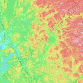
Nom : Carte topographique Kearney, altitude, relief.
Altitude moyenne : 388 m
Altitude minimum : 281 m
Altitude maximum : 542 m
Autres cartes topographiques
Cliquez sur une carte pour visualiser sa topographie, son altitude et son relief.
Key River
Canada > Ontario > Parry Sound District > Unorganized Centre Parry Sound
Altitude moyenne : 194 m
Memesagamesing Lake Dam
Canada > Ontario > Parry Sound District > Unorganized Centre Parry Sound
Altitude moyenne : 227 m
Port Loring
Canada > Ontario > Parry Sound District > Unorganized Centre Parry Sound
Altitude moyenne : 227 m
Stormy Lake
Canada > Ontario > Parry Sound District > Unorganized Centre Parry Sound
Altitude moyenne : 227 m
Bosworth Island
Canada > Ontario > Parry Sound District > Unorganized Centre Parry Sound
Altitude moyenne : 224 m
Dollars Lake
Canada > Ontario > Parry Sound District > Unorganized Centre Parry Sound
Altitude moyenne : 215 m
Moon River
Canada > Ontario > Parry Sound District > The Archipelago Township
Altitude moyenne : 185 m
Pickerel River
Canada > Ontario > Parry Sound District > Unorganized Centre Parry Sound
Altitude moyenne : 200 m
Dokis Island
Canada > Ontario > Parry Sound District > Unorganized Centre Parry Sound
Altitude moyenne : 196 m
Restoule
Canada > Ontario > Parry Sound District > Unorganized Centre Parry Sound
Altitude moyenne : 237 m
Pointe au Baril
Canada > Ontario > Parry Sound District > The Archipelago Township
Altitude moyenne : 177 m
Dollars Lake
Canada > Ontario > Parry Sound District > Unorganized Centre Parry Sound
Altitude moyenne : 215 m
Diamond Lake
Canada > Ontario > Parry Sound District > Seguin Township > Orrville
Altitude moyenne : 273 m
Lake Bernard
Canada > Ontario > Parry Sound District > Strong Township > Sundridge
Altitude moyenne : 347 m
Arnstein
Canada > Ontario > Parry Sound District > Unorganized Centre Parry Sound
Altitude moyenne : 233 m
Ferguson Island
Canada > Ontario > Parry Sound District > Unorganized Centre Parry Sound
Altitude moyenne : 206 m
Manitouwabing Lake
Canada > Ontario > Parry Sound District > McKellar Township > McKellar
Altitude moyenne : 249 m
Whistler Bay
Canada > Ontario > Parry Sound District > Unorganized Centre Parry Sound
Altitude moyenne : 178 m
Key River
Canada > Ontario > Parry Sound District > Unorganized Centre Parry Sound
Altitude moyenne : 193 m
Sundridge
Canada > Ontario > Parry Sound District > Strong Township > Sundridge
Altitude moyenne : 355 m
Moon River
Canada > Ontario > Parry Sound District > The Archipelago Township
Altitude moyenne : 185 m
Nipissing
Canada > Ontario > Parry Sound District > Nipissing Township > Nipissing
Altitude moyenne : 227 m
Recollet Falls
Canada > Ontario > Parry Sound District > Unorganized Centre Parry Sound
Altitude moyenne : 206 m
Orrville
Canada > Ontario > Parry Sound District > Seguin Township > Orrville
Altitude moyenne : 262 m
Magnetawan River
Canada > Ontario > Parry Sound District > Unorganized Centre Parry Sound
Altitude moyenne : 198 m
Key Harbour
Canada > Ontario > Parry Sound District > Unorganized Centre Parry Sound
Altitude moyenne : 178 m
Cole Lake
Canada > Ontario > Parry Sound District > Unorganized Centre Parry Sound
Altitude moyenne : 216 m
Conger Lake
Canada > Ontario > Parry Sound District > The Archipelago Township
Altitude moyenne : 200 m
Deer Horn Island
Canada > Ontario > Parry Sound District > The Archipelago Township
Altitude moyenne : 199 m
Richardson Island
Canada > Ontario > Parry Sound District > Nipissing Township
Altitude moyenne : 194 m
Doe Lake
Canada > Ontario > Parry Sound District > McMurrich/Monteith Township
Altitude moyenne : 303 m
Culin Lake
Canada > Ontario > Parry Sound District > Unorganized Centre Parry Sound > Arnstein
Altitude moyenne : 230 m
Bob's Lake
Canada > Ontario > Parry Sound District > Unorganized Centre Parry Sound
Altitude moyenne : 255 m
Jack's Ridge
Canada > Ontario > Parry Sound District > Unorganized Centre Parry Sound
Altitude moyenne : 254 m
Oastler Lake Provincial Park
Canada > Ontario > Parry Sound District > Seguin Township
Altitude moyenne : 218 m
Golden Valley
Canada > Ontario > Parry Sound District > Unorganized Centre Parry Sound
Altitude moyenne : 243 m
Loring
Canada > Ontario > Parry Sound District > Unorganized Centre Parry Sound
Altitude moyenne : 241 m
Smith Bay
Canada > Ontario > Parry Sound District > Unorganized Centre Parry Sound
Altitude moyenne : 217 m
Watt Island
Canada > Ontario > Parry Sound District > The Archipelago Township
Altitude moyenne : 195 m
Clear Lake
Canada > Ontario > Parry Sound District > Unorganized Centre Parry Sound
Altitude moyenne : 222 m
McNeil's Island
Canada > Ontario > Parry Sound District > Unorganized Centre Parry Sound > Port Loring
Altitude moyenne : 213 m
Skye Island
Canada > Ontario > Parry Sound District > The Archipelago Township
Altitude moyenne : 191 m
Sprucedale
Canada > Ontario > Parry Sound District > McMurrich/Monteith Township
Altitude moyenne : 330 m
Jack's Ridge
Canada > Ontario > Parry Sound District > Unorganized Centre Parry Sound
Altitude moyenne : 254 m
Magee Island
Canada > Ontario > Parry Sound District > Unorganized Centre Parry Sound
Altitude moyenne : 196 m
Jack's Ridge
Canada > Ontario > Parry Sound District > Unorganized Centre Parry Sound
Altitude moyenne : 254 m