
Carte topographique Yangon
Carte interactive
Cliquez sur la carte pour afficher l’altitude.
À propos de cette carte
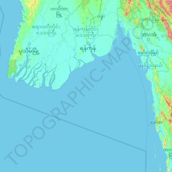
Nom : Carte topographique Yangon, altitude, relief.
Lieu : Yangon, Birmanie (13.77187 93.01251 17.79696 96.82766)
Altitude moyenne : 27 m
Altitude minimum : -3 m
Altitude maximum : 1.955 m
Autres cartes topographiques
Cliquez sur une carte pour visualiser sa topographie, son altitude et son relief.
ကျောက်မြောင်း
Birmanie > Région de Sagaing > Shwebo
ကျောက်မြောင်း, Shwebo, ရွှေဘိုခရိုင်, Région de Sagaing, Birmanie
Altitude moyenne : 99 m
Mandalay
Birmanie > Région de Mandalay > Mandalay
Mandalay, မန္တလေးခရိုင်, Région de Mandalay, 0502-1001, Birmanie
Altitude moyenne : 108 m
Myingyan
Birmanie > Région de Mandalay > Myingyan
Myingyan, မြင်းခြံခရိုင်, Région de Mandalay, 100401, Birmanie
Altitude moyenne : 107 m
Lower Chindwin
Birmanie > Région de Sagaing > ကနီ
Lower Chindwin, ကနီ, ယင်းမာပင်ခရိုင်, Région de Sagaing, Birmanie
Altitude moyenne : 117 m
Mont Popa
Birmanie > Région de Mandalay > ကျောက်ပန်းတောင်း
Mont Popa, ကျောက်ပန်းတောင်း, ညောင်ဦးခရိုင်, Région de Mandalay, Birmanie
Altitude moyenne : 1.094 m
Naypyidaw Territoire de l'Union
Naypyidaw Territoire de l'Union, Birmanie
Altitude moyenne : 445 m
Pyin U Lwin
Birmanie > Région de Mandalay > ပြင်ဦးလွင်ခရိုင်
Pyin U Lwin, ပြင်ဦးလွင်ခရိုင်, Région de Mandalay, Birmanie
Altitude moyenne : 597 m