
Carte topographique Davidson County
Carte interactive
Cliquez sur la carte pour afficher l’altitude.
À propos de cette carte
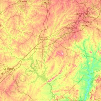
Nom : Carte topographique Davidson County, altitude, relief.
Lieu : Davidson County, North Carolina, United States of America (35.50419 -80.48771 36.02694 -80.04323)
Altitude moyenne : 222 m
Altitude minimum : 111 m
Altitude maximum : 350 m
Davidson County is located entirely within the Piedmont region of central North Carolina. The Piedmont consists of gently rolling terrain frequently broken by hills or shallow valleys formed by rivers and streams. An exception to this terrain are the Uwharrie Mountains in the county's western and southwestern sections. The Uwharries are the oldest mountain range in North America, and at one time they rose to nearly 20,000 feet (6,100 m) above sea level. However, time has worn them down to little more than high hills; yet due to the relative flatness of the surrounding countryside they still rise from 250 to 500 feet (150 m) above their base. The highest point in the Uwharries - and the highest point in Davidson County - is High Rock Mountain in the county's southwestern corner. It has an elevation of 1,119 feet (341 m) above sea level.
Autres cartes topographiques
Cliquez sur une carte pour visualiser sa topographie, son altitude et son relief.
Transylvania County
United States of America > North Carolina
Transylvania County, North Carolina, United States of America
Altitude moyenne : 898 m
Eden
United States of America > North Carolina > Eden
Eden, Rockingham County, North Carolina, 27288, United States of America
Altitude moyenne : 191 m
Brightwater
United States of America > North Carolina > Brightwater
Brightwater, Henderson County, North Carolina, 28791, United States of America
Altitude moyenne : 728 m
Ashe County
United States of America > North Carolina
Ashe County, North Carolina, United States of America
Altitude moyenne : 950 m
Farrington
United States of America > North Carolina > Farrington
Farrington, Chatham County, North Carolina, United States of America
Altitude moyenne : 75 m
Vox
United States of America > North Carolina > Vox
Vox, Alleghany County, North Carolina, United States of America
Altitude moyenne : 828 m
Buncombe County
United States of America > North Carolina
Buncombe County, North Carolina, United States of America
Altitude moyenne : 839 m
Graham County
United States of America > North Carolina
Graham County, North Carolina, United States of America
Altitude moyenne : 850 m
Haywood County
United States of America > North Carolina
Haywood County, North Carolina, United States of America
Altitude moyenne : 1.044 m
Carteret County
United States of America > North Carolina
Carteret County, North Carolina, United States of America
Altitude moyenne : 2 m
Edgecombe County
United States of America > North Carolina
Edgecombe County, North Carolina, United States of America
Altitude moyenne : 28 m
Guilford County
United States of America > North Carolina
Guilford County, North Carolina, United States of America
Altitude moyenne : 239 m
Surry County
United States of America > North Carolina
Surry County, North Carolina, United States of America
Altitude moyenne : 393 m
Appalachian Mountains
United States of America > North Carolina
Appalachian Mountains, Yancey County, North Carolina, United States of America
Altitude moyenne : 1.463 m