Carte topographique Norton
Carte interactive
Cliquez sur la carte pour afficher l’altitude.
À propos de cette carte
![Carte topographique Norton, altitude, relief](/pub/maps/relation/xtkl/s1n518/thumbnail.jpg)
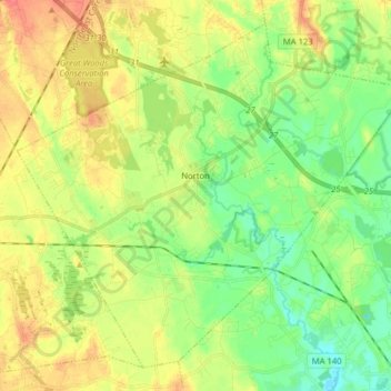
Nom : Carte topographique Norton, altitude, relief.
Lieu : Norton, Bristol County, Massachusetts, 02766, United States (41.90885 -71.25931 42.01261 -71.10085)
Altitude moyenne : 30 m
Altitude minimum : 8 m
Altitude maximum : 56 m
Autres cartes topographiques
Cliquez sur une carte pour visualiser sa topographie, son altitude et son relief.
![Carte topographique Westport, altitude, relief](/pub/maps/relation/lkgp/sx679m/icon.jpg)
Westport
United States > Massachusetts > Bristol County
Westport, Bristol County, Massachusetts, United States
Altitude moyenne : 23 m
![Carte topographique Dartmouth, altitude, relief](/pub/maps/relation/v4tj/fgk9f3/icon.jpg)
Dartmouth
United States > Massachusetts > Bristol County
Dartmouth, Bristol County, Massachusetts, United States
Altitude moyenne : 21 m
![Carte topographique Taunton, altitude, relief](/pub/maps/relation/rxcz/39ggz4/icon.jpg)
Taunton
United States > Massachusetts > Bristol County
Taunton, Bristol County, Massachusetts, United States
Altitude moyenne : 22 m
![Carte topographique Attleboro, altitude, relief](/pub/maps/node/3lgp/xtr313l/icon.jpg)
Attleboro
United States > Massachusetts > Bristol County > Attleboro
Attleboro, Bristol County, Massachusetts, 02703, United States
Altitude moyenne : 40 m
![Carte topographique Fairhaven, altitude, relief](/pub/maps/relation/6w9m/46slmt/icon.jpg)
Fairhaven
United States > Massachusetts > Bristol County
Fairhaven, Bristol County, Massachusetts, 02719, United States
Altitude moyenne : 10 m
![Carte topographique Swansea, altitude, relief](/pub/maps/relation/95zs/chvntj/icon.jpg)
Swansea
United States > Massachusetts > Bristol County
Swansea, Bristol County, Massachusetts, 02777, United States
Altitude moyenne : 19 m
![Carte topographique Attleboro, altitude, relief](/pub/maps/relation/sqmt/6p4ctf/icon.jpg)
Attleboro
United States > Massachusetts > Bristol County
Attleboro, Bristol County, Massachusetts, 02703, United States
Altitude moyenne : 42 m
![Carte topographique Mansfield, altitude, relief](/pub/maps/relation/x1b3/4z19tp/icon.jpg)
Mansfield
United States > Massachusetts > Bristol County
Mansfield, Bristol County, Massachusetts, 02048, United States
Altitude moyenne : 47 m
![Carte topographique North Seekonk, altitude, relief](/pub/maps/node/ln9m/wpnj2tf/icon.jpg)
North Seekonk
United States > Massachusetts > Bristol County > Seekonk
North Seekonk, Seekonk, Bristol County, Massachusetts, 02861, United States
Altitude moyenne : 26 m
![Carte topographique Swansea Center, altitude, relief](/pub/maps/node/p5cz/sqw56gt/icon.jpg)
Swansea Center
United States > Massachusetts > Bristol County > Swansea
Swansea Center, Swansea, Bristol County, Massachusetts, 02725, United States
Altitude moyenne : 15 m
![Carte topographique Westville, altitude, relief](/pub/maps/node/jrr/t9d6ccz/icon.jpg)
Westville
United States > Massachusetts > Bristol County > Taunton
Westville, Taunton, Bristol County, Massachusetts, 02764, United States
Altitude moyenne : 20 m
![Carte topographique Easton, altitude, relief](/pub/maps/relation/nb51/hdkkdn/icon.jpg)
Easton
United States > Massachusetts > Bristol County
Easton, Bristol County, Massachusetts, United States
Altitude moyenne : 47 m
![Carte topographique North Easton, altitude, relief](/pub/maps/node/sfm2/b4ptwt6/icon.jpg)
North Easton
United States > Massachusetts > Bristol County > Easton
North Easton, Easton, Bristol County, Massachusetts, 02356, United States
Altitude moyenne : 53 m
![Carte topographique Peirce, altitude, relief](/pub/maps/relation/p5k/v6pr3l/icon.jpg)
Peirce
United States > Massachusetts > Bristol County > Taunton
Peirce, Taunton, Bristol County, Massachusetts, United States
Altitude moyenne : 23 m
![Carte topographique Monroes, altitude, relief](/pub/maps/node/xp5k/kvqrxf3/icon.jpg)
Monroes
United States > Massachusetts > Bristol County > Seekonk
Monroes, Seekonk, Bristol County, Massachusetts, 02806, United States
Altitude moyenne : 4 m
![Carte topographique Harris, altitude, relief](/pub/maps/node/h3dn/5mpxq57/icon.jpg)
Harris
United States > Massachusetts > Bristol County > Seekonk
Harris, Seekonk, Bristol County, Massachusetts, 02771, United States
Altitude moyenne : 14 m
![Carte topographique Perryville, altitude, relief](/pub/maps/node/3k1h/fcgdlnh/icon.jpg)
Perryville
United States > Massachusetts > Bristol County > Rehoboth
Perryville, Rehoboth, Bristol County, Massachusetts, 02769, United States
Altitude moyenne : 30 m
![Carte topographique Source Is Shapefile From Town, altitude, relief](/pub/maps/way/w257/3b7kzs8/icon.jpg)
Source Is Shapefile From Town
United States > Massachusetts > Bristol County > Mansfield > Robinsonville
Source Is Shapefile From Town, West Street, Robinsonville, Mansfield, Bristol County, Massachusetts, 02048, United States
Altitude moyenne : 50 m
![Carte topographique East Fairhaven, altitude, relief](/pub/maps/node/bc5k/sqwvqgt/icon.jpg)
East Fairhaven
United States > Massachusetts > Bristol County > Fairhaven
East Fairhaven, Fairhaven, Bristol County, Massachusetts, 02719, United States
Altitude moyenne : 10 m
![Carte topographique Perrins Crossing, altitude, relief](/pub/maps/node/wmb3/nks393q/icon.jpg)
Perrins Crossing
United States > Massachusetts > Bristol County > Seekonk
Perrins Crossing, Seekonk, Bristol County, Massachusetts, 02861, United States
Altitude moyenne : 29 m
![Carte topographique North Rehoboth, altitude, relief](/pub/maps/node/lvz4/71j9r18/icon.jpg)
North Rehoboth
United States > Massachusetts > Bristol County > Rehoboth
North Rehoboth, Rehoboth, Bristol County, Massachusetts, United States
Altitude moyenne : 39 m
![Carte topographique Attleborough City, altitude, relief](/pub/maps/node/xm2/v7llxtj/icon.jpg)
Attleborough City
United States > Massachusetts > Bristol County > Attleboro
Attleborough City, Attleboro, Bristol County, Massachusetts, 02861, United States
Altitude moyenne : 35 m
![Carte topographique Raynham, altitude, relief](/pub/maps/relation/mc1h/b1ttnx/icon.jpg)
Raynham
United States > Massachusetts > Bristol County
Raynham, Bristol County, Massachusetts, 02767, United States
Altitude moyenne : 18 m
![Carte topographique Dighton, altitude, relief](/pub/maps/relation/fhnh/db2tzs/icon.jpg)
Dighton
United States > Massachusetts > Bristol County
Dighton, Bristol County, Massachusetts, United States
Altitude moyenne : 18 m
![Carte topographique Pope Beach, altitude, relief](/pub/maps/node/jcz/mb72751/icon.jpg)
Pope Beach
United States > Massachusetts > Bristol County > Fairhaven
Pope Beach, Fairhaven, Bristol County, Massachusetts, 02719, United States
Altitude moyenne : 2 m
![Carte topographique Cranes Station, altitude, relief](/pub/maps/node/ll18/5mpf657/icon.jpg)
Cranes Station
United States > Massachusetts > Bristol County > Norton
Cranes Station, Norton, Bristol County, Massachusetts, 02766, United States
Altitude moyenne : 22 m
![Carte topographique Raynham Center, altitude, relief](/pub/maps/node/1pm2/xtcr8kl/icon.jpg)
Raynham Center
United States > Massachusetts > Bristol County > Raynham
Raynham Center, Raynham, Bristol County, Massachusetts, 02767, United States
Altitude moyenne : 13 m
![Carte topographique Seekonk, altitude, relief](/pub/maps/relation/kcnh/gskpnx/icon.jpg)
Seekonk
United States > Massachusetts > Bristol County
Seekonk, Bristol County, Massachusetts, United States
Altitude moyenne : 19 m
![Carte topographique Camp Merriwood, altitude, relief](/pub/maps/node/dwgt/drbg9z4/icon.jpg)
Camp Merriwood
United States > Massachusetts > Bristol County > Berkley
Camp Merriwood, Berkley, Bristol County, Massachusetts, 02702, United States
Altitude moyenne : 7 m
![Carte topographique Touisset, altitude, relief](/pub/maps/node/4551/v7slntj/icon.jpg)
Touisset
United States > Massachusetts > Bristol County > Swansea
Touisset, Swansea, Bristol County, Massachusetts, 02777, United States
Altitude moyenne : 5 m
![Carte topographique South Rehoboth, altitude, relief](/pub/maps/node/v9m2/v7ld9tj/icon.jpg)
South Rehoboth
United States > Massachusetts > Bristol County > Rehoboth
South Rehoboth, Rehoboth, Bristol County, Massachusetts, United States
Altitude moyenne : 8 m
![Carte topographique Fall River, altitude, relief](/pub/maps/node/8zdn/mvxf43mt/icon.jpg)
Fall River
United States > Massachusetts > Bristol County > Fall River
Fall River, Bristol County, Massachusetts, 02722, United States
Altitude moyenne : 23 m
![Carte topographique New Bedford, altitude, relief](/pub/maps/relation/zvnx/xc5j57/icon.jpg)
New Bedford
United States > Massachusetts > Bristol County
New Bedford, Bristol County, Massachusetts, United States
Altitude moyenne : 21 m
![Carte topographique Fall River, altitude, relief](/pub/maps/relation/36dn/65xwkl/icon.jpg)
Fall River
United States > Massachusetts > Bristol County
Fall River, Bristol County, Massachusetts, United States
Altitude moyenne : 32 m
![Carte topographique Seekonk, altitude, relief](/pub/maps/node/bc57/zs418nx/icon.jpg)
Seekonk
United States > Massachusetts > Bristol County > Seekonk > Seekonk
Seekonk, Bristol County, Massachusetts, 02271, United States
Altitude moyenne : 11 m
![Carte topographique Rehoboth, altitude, relief](/pub/maps/relation/bn4s/lvmqb3/icon.jpg)
Rehoboth
United States > Massachusetts > Bristol County
Rehoboth, Bristol County, Massachusetts, 02769, United States
Altitude moyenne : 27 m
![Carte topographique Sanford Flat, altitude, relief](/pub/maps/node/d44s/jwbpq14/icon.jpg)
Sanford Flat
United States > Massachusetts > Bristol County > Westport
Sanford Flat, Westport, Bristol County, Massachusetts, 02791, United States
Altitude moyenne : 11 m
![Carte topographique Brownell Corner, altitude, relief](/pub/maps/node/7lf3/dr555z4/icon.jpg)
Brownell Corner
United States > Massachusetts > Bristol County > Westport > Brownell Corner
Brownell Corner, Westport, Bristol County, Massachusetts, 02790, United States
Altitude moyenne : 49 m
![Carte topographique Berkley, altitude, relief](/pub/maps/relation/4lm2/lw7ks8/icon.jpg)
Berkley
United States > Massachusetts > Bristol County
Berkley, Bristol County, Massachusetts, 02779, United States
Altitude moyenne : 17 m
![Carte topographique New Bedford, altitude, relief](/pub/maps/node/94zs/lzb1hgp/icon.jpg)
New Bedford
United States > Massachusetts > Bristol County > New Bedford
New Bedford, Bristol County, Massachusetts, 02740, United States
Altitude moyenne : 17 m
![Carte topographique Oakland, altitude, relief](/pub/maps/node/4ccz/3jbxqdn/icon.jpg)
Oakland
United States > Massachusetts > Bristol County > Taunton > Oakland
Oakland, Taunton, Bristol County, Massachusetts, 02780, United States
Altitude moyenne : 19 m
![Carte topographique Kirby Corner, altitude, relief](/pub/maps/node/7ntf/71z2t18/icon.jpg)
Kirby Corner
United States > Massachusetts > Bristol County > Westport > Kirby Corner
Kirby Corner, Westport, Bristol County, Massachusetts, 02790, United States
Altitude moyenne : 33 m
![Carte topographique Acushnet, altitude, relief](/pub/maps/relation/5r57/2mtpcz/icon.jpg)
Acushnet
United States > Massachusetts > Bristol County
Acushnet, Bristol County, Massachusetts, 02743, United States
Altitude moyenne : 21 m
![Carte topographique Rehoboth, altitude, relief](/pub/maps/node/8dz4/9nr9z4s/icon.jpg)
Rehoboth
United States > Massachusetts > Bristol County > Rehoboth > Rehoboth
Rehoboth, Bristol County, Massachusetts, 02769, United States
Altitude moyenne : 26 m
![Carte topographique Fall River Station, altitude, relief](/pub/maps/node/s5mt/wp2vktf/icon.jpg)
Fall River Station
United States > Massachusetts > Bristol County > Fall River > Fall River Station
Fall River Station, Fall River, Bristol County, Massachusetts, 02720-2996, United States
Altitude moyenne : 28 m
![Carte topographique North Attleborough, altitude, relief](/pub/maps/node/d4tp/fcj631h/icon.jpg)
North Attleborough
United States > Massachusetts > Bristol County > North Attleborough > North Attleborough
North Attleborough, Bristol County, Massachusetts, 02760, United States
Altitude moyenne : 65 m
![Carte topographique Old Town Landing, altitude, relief](/pub/maps/node/x257/v73vntj/icon.jpg)
Old Town Landing
United States > Massachusetts > Bristol County > Dighton
Old Town Landing, Dighton, Bristol County, Massachusetts, 02715, United States
Altitude moyenne : 11 m
![Carte topographique Somerset, altitude, relief](/pub/maps/relation/nm3q/ns4mm2/icon.jpg)
Somerset
United States > Massachusetts > Bristol County
Somerset, Bristol County, Massachusetts, United States
Altitude moyenne : 34 m
![Carte topographique Smith Mills, altitude, relief](/pub/maps/node/3snh/mbxpm51/icon.jpg)
Smith Mills
United States > Massachusetts > Bristol County > Dartmouth
Smith Mills, Dartmouth, Bristol County, Massachusetts, 02747, United States
Altitude moyenne : 29 m
![Carte topographique South Dartmouth, altitude, relief](/pub/maps/node/g6b3/nkssq3q/icon.jpg)
South Dartmouth
United States > Massachusetts > Bristol County > Dartmouth > South Dartmouth
South Dartmouth, Dartmouth, Bristol County, Massachusetts, 02748, United States
Altitude moyenne : 3 m