
Carte topographique Nendaz
Carte interactive
Cliquez sur la carte pour afficher l’altitude.
À propos de cette carte
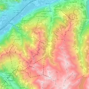
Nom : Carte topographique Nendaz, altitude, relief.
Lieu : Nendaz, Conthey, Wallis, 1997, Switzerland (46.06054 7.24951 46.21142 7.36854)
Altitude moyenne : 1.771 m
Altitude minimum : 465 m
Altitude maximum : 3.319 m
Autres cartes topographiques
Cliquez sur une carte pour visualiser sa topographie, son altitude et son relief.
Vétroz
Switzerland > Wallis > Conthey
Vétroz, Conthey, Wallis, 1963, Switzerland
Altitude moyenne : 920 m
Mayens de My
Switzerland > Wallis > Conthey > Conthey
Mayens de My, Conthey, Wallis, 1964, Switzerland
Altitude moyenne : 1.523 m