
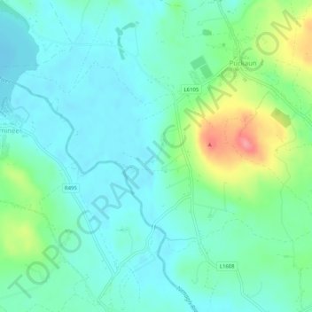
Carte topographique Killadangan
Carte interactive
Cliquez sur la carte pour afficher l’altitude.
À propos de cette carte
Nom : Carte topographique Killadangan, altitude, relief.
Altitude moyenne : 51 m
Altitude minimum : 29 m
Altitude maximum : 116 m
Autres cartes topographiques
Cliquez sur une carte pour visualiser sa topographie, son altitude et son relief.
Ballylusky
Ballylusky, The Municipal District of Nenagh, County Tipperary, Munster, Ireland
Altitude moyenne : 92 m
Cloughjordan
Cloughjordan, Cloghjordan, The Municipal District of Nenagh, County Tipperary, Munster, E53 FD42, Ireland
Altitude moyenne : 97 m
Carrigataha
Carrigataha, Tubbrid, The Municipal District of Cahir — Cashel, County Tipperary, Munster, Ireland
Altitude moyenne : 52 m
Ardfinnan
Ardfinnan, The Municipal District of Cahir — Cashel, County Tipperary, Munster, E91 A7D8, Ireland
Altitude moyenne : 51 m
Cahir
Cahir, The Municipal District of Cahir — Cashel, County Tipperary, Munster, Ireland
Altitude moyenne : 58 m
Gorteennakilla
Gorteennakilla, Youghalarra, The Municipal District of Nenagh, County Tipperary, Munster, Ireland
Altitude moyenne : 57 m
Silvermines
Silvermines, Kilmore, The Municipal District of Nenagh, County Tipperary, Munster, Ireland
Altitude moyenne : 142 m
Shanrahan
Shanrahan, Clogheen, The Municipal District of Cahir — Cashel, County Tipperary, Munster, Ireland
Altitude moyenne : 245 m
Nenagh
Nenagh, The Municipal District of Nenagh, County Tipperary, Munster, Ireland
Altitude moyenne : 59 m
Killoscully
Killoscully, The Municipal District of Nenagh, County Tipperary, Munster, Ireland
Altitude moyenne : 221 m
Clonbullogue
Clonbullogue, The Municipal District of Cahir — Cashel, County Tipperary, Munster, E34 DP79, Ireland
Altitude moyenne : 123 m
Newtownlennan
Newtownlennan, Carrick-on-Suir Urban, The Municipal District of Carrick-on-Suir, County Tipperary, Munster, Ireland
Altitude moyenne : 23 m
Carrick-on-Suir
Carrick-on-Suir, County Tipperary, Munster, Ireland
Altitude moyenne : 41 m
Ballytarsna (Hackett)
Ballytarsna (Hackett), Ballysheehan, The Municipal District of Carrick-on-Suir, County Tipperary, Munster, Ireland
Altitude moyenne : 117 m
Templemore
Templemore, The Municipal District of Thurles, County Tipperary, Munster, Ireland
Altitude moyenne : 115 m
Carrig
Carrig, The Municipal District of Nenagh, County Tipperary, Munster, Ireland
Altitude moyenne : 53 m
Lough Derg
Lough Derg, County Tipperary, Munster, Ireland
Altitude moyenne : 87 m
Ballymackey
Ballymackey, The Municipal District of Nenagh, County Tipperary, Munster, Ireland
Altitude moyenne : 113 m
Sharragh
Sharragh, Graigue, The Municipal District of Nenagh, County Tipperary, Munster, Ireland
Altitude moyenne : 62 m
Glencarbry
Glencarbry, Donohill, The Municipal District of Cahir — Cashel, County Tipperary, Munster, Ireland
Altitude moyenne : 303 m
Clogheen
Clogheen, The Municipal District of Cahir — Cashel, County Tipperary, Munster, E21 XD23, Ireland
Altitude moyenne : 65 m
Thurles
Thurles, The Municipal District of Thurles, County Tipperary, Munster, Ireland
Altitude moyenne : 101 m
Cashel
Cashel, The Municipal District of Cahir — Cashel, County Tipperary, Munster, Ireland
Altitude moyenne : 115 m
Upperchurch
Upperchurch, The Municipal District of Thurles, County Tipperary, Munster, Ireland
Altitude moyenne : 231 m
Lisronagh
Lisronagh, The Borough District of Clonmel, County Tipperary, Munster, Ireland
Altitude moyenne : 73 m
Knockgraffon
Knockgraffon, The Municipal District of Cahir — Cashel, County Tipperary, Munster, Ireland
Altitude moyenne : 86 m
Kilsheelan
Kilsheelan, County Tipperary, Munster, Ireland
Altitude moyenne : 49 m
Moyaliffe Parish
Moyaliffe Parish, The Municipal District of Thurles, County Tipperary, Munster, Ireland
Altitude moyenne : 163 m
Kilmolash Upper
Kilmolash Upper, Ballyclerahan, The Borough District of Clonmel, County Tipperary, Munster, Ireland
Altitude moyenne : 109 m
Ardcroney Parish
Ardcroney Parish, The Municipal District of Nenagh, County Tipperary, Munster, Ireland
Altitude moyenne : 79 m
Clonmel
Ireland > County Tipperary > Clonmel
Clonmel, The Borough District of Clonmel, County Tipperary, Munster, E91N512, Ireland
Altitude moyenne : 106 m
Ballina
Ballina, The Municipal District of Nenagh, County Tipperary, Munster, Ireland
Altitude moyenne : 71 m
Newcastle
Newcastle, The Municipal District of Cahir — Cashel, County Tipperary, Munster, Ireland
Altitude moyenne : 178 m
Ballingarry Lower
Ballingarry Lower, Ballingarry, The Municipal District of Carrick-on-Suir, County Tipperary, Munster, Ireland
Altitude moyenne : 177 m
The Borough District of Clonmel
The Borough District of Clonmel, County Tipperary, Munster, Ireland
Altitude moyenne : 118 m
Lismalin
Lismalin, Ballingarry, The Municipal District of Carrick-on-Suir, County Tipperary, Munster, Ireland
Altitude moyenne : 121 m
Cashel
Cashel, Cashel Urban, The Municipal District of Cahir — Cashel, County Tipperary, Munster, E25 CX21, Ireland
Altitude moyenne : 114 m
Ballycommon
Ballycommon, The Municipal District of Nenagh, County Tipperary, Munster, E45 TH93, Ireland
Altitude moyenne : 48 m
Knockanglass
Knockanglass, Buolick, The Municipal District of Thurles, County Tipperary, Munster, Ireland
Altitude moyenne : 239 m
Graigaheesha
Graigaheesha, Kilcooly, The Municipal District of Thurles, County Tipperary, Munster, Ireland
Altitude moyenne : 160 m
Lackandarra
Lackandarra, Gortkelly, The Municipal District of Thurles, County Tipperary, Munster, Ireland
Altitude moyenne : 116 m
Gortnahoo
Gortnahoo, Buolick, The Municipal District of Thurles, County Tipperary, Munster, Ireland
Altitude moyenne : 135 m
Terryglass
Terryglass, The Municipal District of Nenagh, County Tipperary, Munster, Ireland
Altitude moyenne : 43 m
Derrycarney
Derrycarney, Ballymackey, The Municipal District of Nenagh, County Tipperary, Munster, Ireland
Altitude moyenne : 104 m
The Municipal District of Cahir — Cashel
The Municipal District of Cahir — Cashel, County Tipperary, Munster, E34 DF43, Ireland, Curragh
Altitude moyenne : 214 m
Crohane Lower
Crohane Lower, Crohane, The Municipal District of Carrick-on-Suir, County Tipperary, Munster, Ireland
Altitude moyenne : 171 m
Ballingarry
Ballingarry, The Municipal District of Carrick-on-Suir, County Tipperary, Munster, Ireland
Altitude moyenne : 183 m
Lisvarrinane
Lisvarrinane, Clonbeg, The Municipal District of Cahir — Cashel, County Tipperary, Munster, Ireland
Altitude moyenne : 189 m
Ballykisteen
Ballykisteen, The Municipal District of Cahir — Cashel, County Tipperary, Munster, E34 Y621, Ireland
Altitude moyenne : 95 m