
Faire un don
Équipez-vous pour votre prochaine aventure :
En tant que Partenaire Amazon, ce site perçoit une commission sur les achats éligibles sans surcoût pour vous.
Carte topographique Montgomery Center
Cliquez sur la carte pour afficher l’altitude.
Faire un don
Équipez-vous pour votre prochaine aventure :
En tant que Partenaire Amazon, ce site perçoit une commission sur les achats éligibles sans surcoût pour vous.
À propos de cette carte
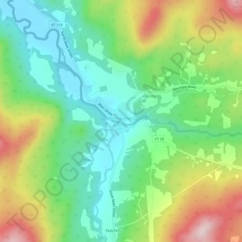
Nom : Carte topographique Montgomery Center, altitude, relief.
Altitude moyenne : 269 m
Altitude minimum : 143 m
Altitude maximum : 487 m
Faire un don
Équipez-vous pour votre prochaine aventure :
En tant que Partenaire Amazon, ce site perçoit une commission sur les achats éligibles sans surcoût pour vous.
Autres cartes topographiques
Cliquez sur une carte pour visualiser sa topographie, son altitude et son relief.
Fletcher
United States > Vermont > Franklin County
Fletcher is located in southern Franklin County, bordered to the southeast by Lamoille County. According to the United States Census Bureau, the town has a total area of 38.0 square miles (98.4 km2), of which 37.7 square miles (97.7 km2) is land and 0.3 square miles (0.7 km2), or 0.71%, is water. The Lamoille…
Altitude moyenne : 229 m
Faire un don
Équipez-vous pour votre prochaine aventure :
En tant que Partenaire Amazon, ce site perçoit une commission sur les achats éligibles sans surcoût pour vous.
Missisquoi River
United States > Vermont > Franklin County
The Missisquoi River rises in western Orleans County, Vermont, northwest of Lowell, Vermont, at an altitude of 247 metres (810 ft). This source is located next to Route 58 and adjacent to Belvidere Mountain. This source proves to be the continuity of the Burgess Branch (coming from the southwest).
Altitude moyenne : 277 m
Faire un don
Équipez-vous pour votre prochaine aventure :
En tant que Partenaire Amazon, ce site perçoit une commission sur les achats éligibles sans surcoût pour vous.
Fletcher
United States > Vermont > Franklin County
Fletcher is located in southern Franklin County, bordered to the southeast by Lamoille County. According to the United States Census Bureau, the town has a total area of 38.0 square miles (98.4 km2), of which 37.7 square miles (97.7 km2) is land and 0.3 square miles (0.7 km2), or 0.71%, is water. The Lamoille…
Altitude moyenne : 229 m
Faire un don
Équipez-vous pour votre prochaine aventure :
En tant que Partenaire Amazon, ce site perçoit une commission sur les achats éligibles sans surcoût pour vous.