
Faire un don
Équipez-vous pour votre prochaine aventure :
En tant que Partenaire Amazon, ce site perçoit une commission sur les achats éligibles sans surcoût pour vous.
Carte topographique Hurunui River
Cliquez sur la carte pour afficher l’altitude.
Faire un don
Équipez-vous pour votre prochaine aventure :
En tant que Partenaire Amazon, ce site perçoit une commission sur les achats éligibles sans surcoût pour vous.
À propos de cette carte
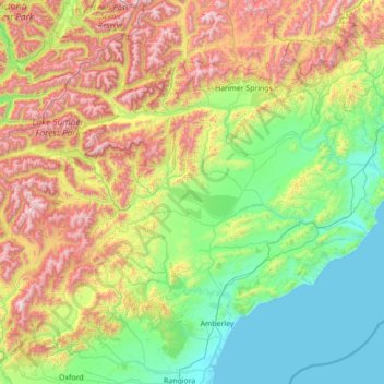
Nom : Carte topographique Hurunui River, altitude, relief.
Lieu : Hurunui River, Canterbury, New Zealand (-42.91184 171.88524 -42.69188 173.28427)
Altitude moyenne : 584 m
Altitude minimum : 0 m
Altitude maximum : 2.001 m
Faire un don
Équipez-vous pour votre prochaine aventure :
En tant que Partenaire Amazon, ce site perçoit une commission sur les achats éligibles sans surcoût pour vous.
Autres cartes topographiques
Cliquez sur une carte pour visualiser sa topographie, son altitude et son relief.
Faire un don
Équipez-vous pour votre prochaine aventure :
En tant que Partenaire Amazon, ce site perçoit une commission sur les achats éligibles sans surcoût pour vous.
Ashburton
New Zealand > Canterbury > Ashburton District
On the whole, Ashburton shares a similar climate to Christchurch i.e. a dry temperate climate (Cfb). However, since it lies further inland at a higher altitude than Christchurch, Ashburton experiences a greater range of temperatures. Summers in Ashburton can be warm, seeing an average of 39 days exceeding 25…
Altitude moyenne : 99 m
Akaroa
New Zealand > Canterbury > Christchurch City > Banks Peninsula Community
Altitude moyenne : 108 m
Faire un don
Équipez-vous pour votre prochaine aventure :
En tant que Partenaire Amazon, ce site perçoit une commission sur les achats éligibles sans surcoût pour vous.
Mount Cook
New Zealand > Canterbury > Mackenzie District
Aoraki / Mount Cook is the highest mountain in New Zealand. Its height, as of 2014, is listed as 3,724 metres (12,218 feet). It is situated in the Southern Alps, the mountain range that runs the length of the South Island. A popular tourist destination, it is also a favourite challenge for mountaineers. Aoraki…
Altitude moyenne : 2.920 m
Faire un don
Équipez-vous pour votre prochaine aventure :
En tant que Partenaire Amazon, ce site perçoit une commission sur les achats éligibles sans surcoût pour vous.
Ashburton
New Zealand > Canterbury > Ashburton District
On the whole, Ashburton shares a similar climate to Christchurch i.e. a dry temperate climate (Cfb). However, since it lies further inland at a higher altitude to Christchurch, Ashburton experiences a greater range of temperatures. During summer Ashburton can exceed 30 °C (86 °F), whilst winter can see…
Altitude moyenne : 99 m
Takamatua
New Zealand > Canterbury > Christchurch City > Banks Peninsula Community
Altitude moyenne : 101 m
Fairlie
New Zealand > Canterbury > Mackenzie District
Fairlie is a Mackenzie District service town (or township) located in the Canterbury region of the South Island of New Zealand. The estimated population was 960 as of June 2024. Being on state highway 8 between Christchurch (182 km, 2 hours 20 minutes drive) and Queenstown (300 km 3.5 hours drive), tourism is…
Altitude moyenne : 317 m
Faire un don
Équipez-vous pour votre prochaine aventure :
En tant que Partenaire Amazon, ce site perçoit une commission sur les achats éligibles sans surcoût pour vous.
Faire un don
Équipez-vous pour votre prochaine aventure :
En tant que Partenaire Amazon, ce site perçoit une commission sur les achats éligibles sans surcoût pour vous.
Mount Cook
New Zealand > Canterbury > Mackenzie District
Aoraki / Mount Cook is the highest mountain in New Zealand. Its height, as of 2014, is listed as 3,724 metres (12,218 feet). It is situated in the Southern Alps, the mountain range that runs the length of the South Island. A popular tourist destination, it is also a favourite challenge for mountaineers. Aoraki…
Altitude moyenne : 2.920 m
Faire un don
Équipez-vous pour votre prochaine aventure :
En tant que Partenaire Amazon, ce site perçoit une commission sur les achats éligibles sans surcoût pour vous.
Faire un don
Équipez-vous pour votre prochaine aventure :
En tant que Partenaire Amazon, ce site perçoit une commission sur les achats éligibles sans surcoût pour vous.
Faire un don
Équipez-vous pour votre prochaine aventure :
En tant que Partenaire Amazon, ce site perçoit une commission sur les achats éligibles sans surcoût pour vous.
Faire un don
Équipez-vous pour votre prochaine aventure :
En tant que Partenaire Amazon, ce site perçoit une commission sur les achats éligibles sans surcoût pour vous.
Methven
New Zealand > Canterbury > Ashburton District
Methven (Māori: Piwakawaka) is a small town in the Canterbury region of the South Island of New Zealand. It is located near the western edge of the Canterbury Plains, 35 km (22 mi) north of Ashburton and 95 km (59 mi) west of Christchurch, and at an elevation of 320 m (1,050 ft). The town is a service centre…
Altitude moyenne : 322 m
Faire un don
Équipez-vous pour votre prochaine aventure :
En tant que Partenaire Amazon, ce site perçoit une commission sur les achats éligibles sans surcoût pour vous.
Un named plug
New Zealand > Canterbury > Christchurch City > Banks Peninsula Community > Diamond Harbour
Altitude moyenne : 164 m
Faire un don
Équipez-vous pour votre prochaine aventure :
En tant que Partenaire Amazon, ce site perçoit une commission sur les achats éligibles sans surcoût pour vous.
Faire un don
Équipez-vous pour votre prochaine aventure :
En tant que Partenaire Amazon, ce site perçoit une commission sur les achats éligibles sans surcoût pour vous.
Faire un don
Équipez-vous pour votre prochaine aventure :
En tant que Partenaire Amazon, ce site perçoit une commission sur les achats éligibles sans surcoût pour vous.
Barrys Bay
New Zealand > Canterbury > Christchurch City > Banks Peninsula Community
Altitude moyenne : 100 m
Faire un don
Équipez-vous pour votre prochaine aventure :
En tant que Partenaire Amazon, ce site perçoit une commission sur les achats éligibles sans surcoût pour vous.
Haytor
New Zealand > Canterbury > Christchurch City > Banks Peninsula Community
Altitude moyenne : 348 m
Faire un don
Équipez-vous pour votre prochaine aventure :
En tant que Partenaire Amazon, ce site perçoit une commission sur les achats éligibles sans surcoût pour vous.
Mount Cook
New Zealand > Canterbury > Mackenzie District
Temperatures at the mountain's base in the Hooker Valley around 800 metres (2,600 feet) range from −13 °C (9 °F) to 32 °C (90 °F), and generally fall just over 1 °C for every 200 metres of altitude.
Altitude moyenne : 2.920 m
Faire un don
Équipez-vous pour votre prochaine aventure :
En tant que Partenaire Amazon, ce site perçoit une commission sur les achats éligibles sans surcoût pour vous.
Faire un don
Équipez-vous pour votre prochaine aventure :
En tant que Partenaire Amazon, ce site perçoit une commission sur les achats éligibles sans surcoût pour vous.
Brasenose
New Zealand > Canterbury > Christchurch City > Banks Peninsula Community
Altitude moyenne : 483 m
Faire un don
Équipez-vous pour votre prochaine aventure :
En tant que Partenaire Amazon, ce site perçoit une commission sur les achats éligibles sans surcoût pour vous.
New Brighton Beach
New Zealand > Canterbury > Christchurch City > Coastal-Burwood Community
Altitude moyenne : 4 m
Styx Mill Conservation Reserve
New Zealand > Canterbury > Christchurch City > Christchurch
Altitude moyenne : 14 m
Faire un don
Équipez-vous pour votre prochaine aventure :
En tant que Partenaire Amazon, ce site perçoit une commission sur les achats éligibles sans surcoût pour vous.
Faire un don
Équipez-vous pour votre prochaine aventure :
En tant que Partenaire Amazon, ce site perçoit une commission sur les achats éligibles sans surcoût pour vous.