
Carte topographique Canowindra
Cliquez sur la carte pour afficher l’altitude.
À propos de cette carte
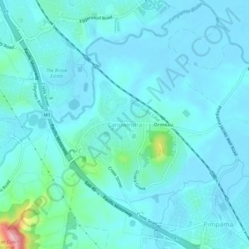
Nom : Carte topographique Canowindra, altitude, relief.
Lieu : Canowindra, Gold Coast City, Queensland, 4208, Australia (-27.82017 153.25541 -27.78017 153.29541)
Altitude moyenne : 20 m
Altitude minimum : 1 m
Altitude maximum : 162 m
Autres cartes topographiques
Cliquez sur une carte pour visualiser sa topographie, son altitude et son relief.
Guanaba
Australia > Queensland > Gold Coast City
The eastern boundary of Guanaba follows the Coomera River. Tamborine National Park occupies a section in the west where elevations reach to around 40 metres (130 ft) above sea level.
Altitude moyenne : 154 m