
Faire un don
Équipez-vous pour votre prochaine aventure :
En tant que Partenaire Amazon, ce site perçoit une commission sur les achats éligibles sans surcoût pour vous.
Carte topographique Molamenqing
Cliquez sur la carte pour afficher l’altitude.
Faire un don
Équipez-vous pour votre prochaine aventure :
En tant que Partenaire Amazon, ce site perçoit une commission sur les achats éligibles sans surcoût pour vous.
Molamenqing
Molamenqing, also known as Phola Gangchen, is an eastern outlier of Shishapangma, the 14th-highest peak in the world. Both are in the Jugal Himal, a subrange of the Himalaya in Tibet. (This range is contiguous with, and often considered a part of, the Langtang Himal.) Its elevation is also given as 7,661 m (25,135 ft); the elevation given here is from a Chinese survey. Molamenqing is little-known, partly since it does not have much independent stature. Its topographic prominence, i.e. its rise above the saddle connecting it with Shishapangma, is only 430 metres, which is relatively small for a Himalayan peak, although large enough for it to qualify in some reckonings as an independent peak.
Faire un don
Équipez-vous pour votre prochaine aventure :
En tant que Partenaire Amazon, ce site perçoit une commission sur les achats éligibles sans surcoût pour vous.
À propos de cette carte
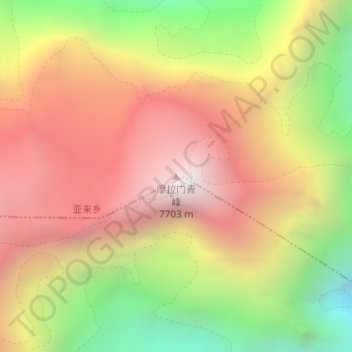
Nom : Carte topographique Molamenqing, altitude, relief.
Altitude moyenne : 6.756 m
Altitude minimum : 5.658 m
Altitude maximum : 7.655 m
Faire un don
Équipez-vous pour votre prochaine aventure :
En tant que Partenaire Amazon, ce site perçoit une commission sur les achats éligibles sans surcoût pour vous.