
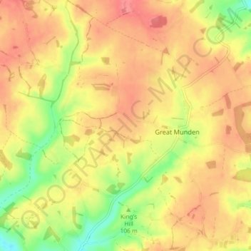
Carte topographique Great Munden
Carte interactive
Cliquez sur la carte pour afficher l’altitude.
À propos de cette carte
Nom : Carte topographique Great Munden, altitude, relief.
Altitude moyenne : 114 m
Altitude minimum : 74 m
Altitude maximum : 138 m
Autres cartes topographiques
Cliquez sur une carte pour visualiser sa topographie, son altitude et son relief.
Ware
United Kingdom > England > Hertfordshire > East Hertfordshire
Ware, East Hertfordshire, Hertfordshire, England, United Kingdom
Altitude moyenne : 55 m
Astonbury Wood
United Kingdom > England > Hertfordshire > East Hertfordshire > Aston
Astonbury Wood, Aston, East Hertfordshire, Hertfordshire, England, United Kingdom
Altitude moyenne : 83 m
Stanstead St Margarets
United Kingdom > England > Hertfordshire > East Hertfordshire
Stanstead St Margarets, East Hertfordshire, Hertfordshire, England, SG12 8DH, United Kingdom
Altitude moyenne : 48 m
Burnham Green
United Kingdom > England > Hertfordshire > East Hertfordshire
Burnham Green, East Hertfordshire, Hertfordshire, England, AL6 0HA, United Kingdom
Altitude moyenne : 102 m
Furneux Pelham
United Kingdom > England > Hertfordshire > East Hertfordshire
Furneux Pelham, East Hertfordshire, Hertfordshire, England, United Kingdom
Altitude moyenne : 113 m
Chapmore End
United Kingdom > England > Hertfordshire > East Hertfordshire > Tonwell
Chapmore End, Bengeo Rural, Tonwell, East Hertfordshire, Hertfordshire, England, SG12 0HF, United Kingdom
Altitude moyenne : 65 m
Benington
United Kingdom > England > Hertfordshire > East Hertfordshire
Benington, East Hertfordshire, Hertfordshire, England, SG2 7LA, United Kingdom
Altitude moyenne : 106 m
King's Meads
United Kingdom > England > Hertfordshire > East Hertfordshire > Ware
King's Meads, Glaxo Footbridge, Kings Hill, Ware, East Hertfordshire, Hertfordshire, England, SG12 0GG, United Kingdom
Altitude moyenne : 53 m
Broken Green
United Kingdom > England > Hertfordshire > East Hertfordshire
Broken Green, Standon, East Hertfordshire, Hertfordshire, England, SG11 1NH, United Kingdom
Altitude moyenne : 97 m
Little Amwell
United Kingdom > England > Hertfordshire > East Hertfordshire
Little Amwell, East Hertfordshire, Hertfordshire, England, SG13 7QX, United Kingdom
Altitude moyenne : 65 m
Spellbrook
United Kingdom > England > Hertfordshire > East Hertfordshire > Sawbridgeworth
Spellbrook, Sawbridgeworth, East Hertfordshire, Hertfordshire, England, CM23 4RE, United Kingdom
Altitude moyenne : 71 m
Westmill
United Kingdom > England > Hertfordshire > East Hertfordshire
Westmill, East Hertfordshire, Hertfordshire, England, United Kingdom
Altitude moyenne : 108 m
Hertingfordbury
United Kingdom > England > Hertfordshire > East Hertfordshire
Hertingfordbury, East Hertfordshire, Hertfordshire, England, SG14 2LD, United Kingdom
Altitude moyenne : 61 m
Bishop's Stortford
United Kingdom > England > Hertfordshire > East Hertfordshire
Bishop's Stortford, East Hertfordshire, Hertfordshire, England, United Kingdom
Altitude moyenne : 83 m
Aston
United Kingdom > England > Hertfordshire > East Hertfordshire
Aston, East Hertfordshire, Hertfordshire, England, United Kingdom
Altitude moyenne : 99 m
Tewin Wood
United Kingdom > England > Hertfordshire > East Hertfordshire > Burnham Green
Tewin Wood, Tewin, Burnham Green, East Hertfordshire, Hertfordshire, England, AL6 0NU, United Kingdom
Altitude moyenne : 101 m
Puckeridge
United Kingdom > England > Hertfordshire > East Hertfordshire
Puckeridge, East Hertfordshire, Hertfordshire, England, SG11 1RD, United Kingdom
Altitude moyenne : 98 m
Wyddial
United Kingdom > England > Hertfordshire > East Hertfordshire
Wyddial, East Hertfordshire, Hertfordshire, England, SG9 0UH, United Kingdom
Altitude moyenne : 114 m
Throcking
United Kingdom > England > Hertfordshire > East Hertfordshire > Buntingford
Throcking, Cottered, Buntingford, East Hertfordshire, Hertfordshire, England, SG9 9RU, United Kingdom
Altitude moyenne : 126 m
Hertford
United Kingdom > England > Hertfordshire > East Hertfordshire
Hertford, East Hertfordshire, Hertfordshire, England, United Kingdom
Altitude moyenne : 61 m
Bayford
United Kingdom > England > Hertfordshire > East Hertfordshire
Bayford, East Hertfordshire, Hertfordshire, England, United Kingdom
Altitude moyenne : 83 m
Braughing
United Kingdom > England > Hertfordshire > East Hertfordshire
Braughing, East Hertfordshire, Hertfordshire, England, United Kingdom
Altitude moyenne : 104 m
Moor Green
United Kingdom > England > Hertfordshire > East Hertfordshire > Ardeley
Moor Green, Ardeley, East Hertfordshire, Hertfordshire, England, SG2 7AS, United Kingdom
Altitude moyenne : 123 m
Hertingfordbury
United Kingdom > England > Hertfordshire > East Hertfordshire
Hertingfordbury, East Hertfordshire, Hertfordshire, England, United Kingdom
Altitude moyenne : 68 m
Gilston
United Kingdom > England > Hertfordshire > East Hertfordshire
Gilston, East Hertfordshire, Hertfordshire, England, United Kingdom
Altitude moyenne : 59 m
Letty Green
United Kingdom > England > Hertfordshire > East Hertfordshire
Letty Green, East Hertfordshire, Hertfordshire, England, SG14 2NS, United Kingdom
Altitude moyenne : 69 m
Dassels
United Kingdom > England > Hertfordshire > East Hertfordshire > Dassels
Dassels, East Hertfordshire, Hertfordshire, East of England, England, SG11 2RW, United Kingdom
Altitude moyenne : 104 m
Buntingford
United Kingdom > England > Hertfordshire > East Hertfordshire
Buntingford, East Hertfordshire, Hertfordshire, England, United Kingdom
Altitude moyenne : 110 m
Hertford Heath Nature Reserve
United Kingdom > England > Hertfordshire > East Hertfordshire > Little Amwell
Hertford Heath Nature Reserve, Bride's Farm, Hertford Heath, Little Amwell, East Hertfordshire, Hertfordshire, England, United Kingdom
Altitude moyenne : 79 m
Painter's Green
United Kingdom > England > Hertfordshire > East Hertfordshire > Datchworth
Painter's Green, Datchworth, East Hertfordshire, Hertfordshire, England, SG3 6ST, United Kingdom
Altitude moyenne : 100 m
Hare Street
United Kingdom > England > Hertfordshire > East Hertfordshire > Great Hormead
Hare Street, Hormead, Great Hormead, East Hertfordshire, Hertfordshire, England, SG9 0DZ, United Kingdom
Altitude moyenne : 110 m
Standon
United Kingdom > England > Hertfordshire > East Hertfordshire
Standon, East Hertfordshire, Hertfordshire, England, United Kingdom
Altitude moyenne : 97 m
Waterford
United Kingdom > England > Hertfordshire > East Hertfordshire > Waterford
Waterford, East Hertfordshire, Hertfordshire, East of England, England, SG14 2PR, United Kingdom
Altitude moyenne : 66 m
Sawbridgeworth
United Kingdom > England > Hertfordshire > East Hertfordshire > Sawbridgeworth
Sawbridgeworth, East Hertfordshire, Hertfordshire, England, United Kingdom
Altitude moyenne : 67 m
Meesden
United Kingdom > England > Hertfordshire > East Hertfordshire
Meesden, East Hertfordshire, Hertfordshire, England, United Kingdom
Altitude moyenne : 126 m
Hertford Heath
United Kingdom > England > Hertfordshire > East Hertfordshire
Hertford Heath, Little Amwell, East Hertfordshire, Hertfordshire, England, United Kingdom
Altitude moyenne : 74 m
Baker's End
United Kingdom > England > Hertfordshire > East Hertfordshire > Wareside > Baker's End
Baker's End, Wareside, East Hertfordshire, Hertfordshire, East of England, England, SG12 7SH, United Kingdom
Altitude moyenne : 73 m
Tewin
United Kingdom > England > Hertfordshire > East Hertfordshire
Tewin, East Hertfordshire, Hertfordshire, England, United Kingdom
Altitude moyenne : 91 m
Much Hadham
United Kingdom > England > Hertfordshire > East Hertfordshire
Much Hadham, East Hertfordshire, Hertfordshire, England, United Kingdom
Altitude moyenne : 80 m
Widford
United Kingdom > England > Hertfordshire > East Hertfordshire
Widford, East Hertfordshire, Hertfordshire, England, United Kingdom
Altitude moyenne : 73 m
Thorley
United Kingdom > England > Hertfordshire > East Hertfordshire
Thorley, East Hertfordshire, Hertfordshire, England, United Kingdom
Altitude moyenne : 82 m
High Wych
United Kingdom > England > Hertfordshire > East Hertfordshire
High Wych, East Hertfordshire, Hertfordshire, England, United Kingdom
Altitude moyenne : 70 m
Little Berkhamsted
United Kingdom > England > Hertfordshire > East Hertfordshire
Little Berkhamsted, East Hertfordshire, Hertfordshire, England, United Kingdom
Altitude moyenne : 88 m
Little Hadham
United Kingdom > England > Hertfordshire > East Hertfordshire
Little Hadham, East Hertfordshire, Hertfordshire, England, SG11 2DG, United Kingdom
Altitude moyenne : 96 m
Brent Pelham
United Kingdom > England > Hertfordshire > East Hertfordshire
Brent Pelham, East Hertfordshire, Hertfordshire, England, SG9 0HN, United Kingdom
Altitude moyenne : 121 m
Great Amwell
United Kingdom > England > Hertfordshire > East Hertfordshire
Great Amwell, East Hertfordshire, Hertfordshire, England, SG12 9SW, United Kingdom
Altitude moyenne : 53 m
Epping Green
United Kingdom > England > Hertfordshire > East Hertfordshire
Epping Green, East Hertfordshire, Hertfordshire, England, SG13 8NG, United Kingdom
Altitude moyenne : 103 m
Walkern
United Kingdom > England > Hertfordshire > East Hertfordshire
Walkern, East Hertfordshire, Hertfordshire, England, United Kingdom
Altitude moyenne : 112 m
Wadesmill
United Kingdom > England > Hertfordshire > East Hertfordshire
Wadesmill, East Hertfordshire, Hertfordshire, England, SG12 0TY, United Kingdom
Altitude moyenne : 78 m
Brickendon
United Kingdom > England > Hertfordshire > East Hertfordshire
Brickendon, East Hertfordshire, Hertfordshire, England, SG13 8PF, United Kingdom
Altitude moyenne : 87 m