
Faire un don
Équipez-vous pour votre prochaine aventure :
En tant que Partenaire Amazon, ce site perçoit une commission sur les achats éligibles sans surcoût pour vous.
Carte topographique Dicinisio
Cliquez sur la carte pour afficher l’altitude.
Faire un don
Équipez-vous pour votre prochaine aventure :
En tant que Partenaire Amazon, ce site perçoit une commission sur les achats éligibles sans surcoût pour vous.
À propos de cette carte
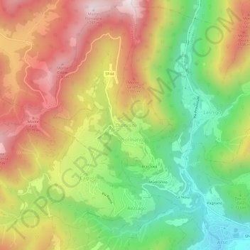
Nom : Carte topographique Dicinisio, altitude, relief.
Lieu : Dicinisio, Sormano, Como, Lombardy, 22030, Italy (45.86005 9.22706 45.90005 9.26706)
Altitude moyenne : 831 m
Altitude minimum : 407 m
Altitude maximum : 1.291 m
Faire un don
Équipez-vous pour votre prochaine aventure :
En tant que Partenaire Amazon, ce site perçoit une commission sur les achats éligibles sans surcoût pour vous.
Autres cartes topographiques
Cliquez sur une carte pour visualiser sa topographie, son altitude et son relief.
Lake Como
Lake Como weather is humid subtropical (Cfa in the Köppen climate classification). In winter, the lake helps to maintain a higher temperature in the surrounding region. Average daily temperatures range from ~3.7 °C (39 °F) in January to 23.4 °C (74 °F) in July, according to historical weather data from…
Altitude moyenne : 885 m
Faire un don
Équipez-vous pour votre prochaine aventure :
En tant que Partenaire Amazon, ce site perçoit une commission sur les achats éligibles sans surcoût pour vous.