
Carte topographique Oslob
Cliquez sur la carte pour afficher l’altitude.
Oslob
Generally, the area's topography is hilly and rolling, dominated by open grasslands and second-growth forests. There are fairly level and rolling plateaus and valleys spread throughout the interior. These are some of the most suitable areas for upland agriculture. The highest mountain peak is 800 metres (2,600 ft) above sea level.
À propos de cette carte
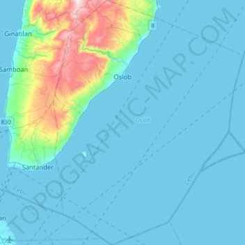
Nom : Carte topographique Oslob, altitude, relief.
Lieu : Oslob, Cebu, Central Visayas, 6025, Philippines (9.32234 123.35292 9.60805 123.57381)
Altitude moyenne : 96 m
Altitude minimum : 0 m
Altitude maximum : 868 m
Autres cartes topographiques
Cliquez sur une carte pour visualiser sa topographie, son altitude et son relief.
Carcar
The land is generally level with less than 18% slope comprising 78.7% of the total land area. Areas with slopes ranging from 18 to 50% cover 19.3% of the total land area and those over 50% slope comprise approximately 1.9%. The highest recorded elevation is a little over 660 metres (2,170 ft) above sea level,…
Altitude moyenne : 97 m
Catmon
Catmon's topography is generally mountainous and hilly but patches of flat lands can be found along the coastline and portion of the poblacion. The municipality's climate is of Coronas climate type IV, where rainfall is evenly distributed throughout the year. Mount Capayas (Kapayas) (also known as Tore Peak),…
Altitude moyenne : 67 m
Balamban
Farming is another source of livelihood for residents with corn, crops and vegetables among the important crops. The municipality is also the only source of abaca fibers in Cebu produced in a 260-to-300-hectare (640-to-740-acre) plantation in Mount Manunggal in barangay Magsaysay. With the elevation of 500…
Altitude moyenne : 28 m