
Faire un don
Équipez-vous pour votre prochaine aventure :
En tant que Partenaire Amazon, ce site perçoit une commission sur les achats éligibles sans surcoût pour vous.
Carte topographique Canehill
Cliquez sur la carte pour afficher l’altitude.
Faire un don
Équipez-vous pour votre prochaine aventure :
En tant que Partenaire Amazon, ce site perçoit une commission sur les achats éligibles sans surcoût pour vous.
À propos de cette carte
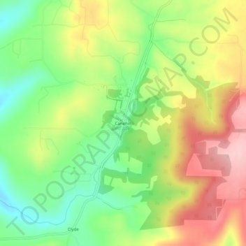
Nom : Carte topographique Canehill, altitude, relief.
Lieu : Canehill, Washington County, Arkansas, United States (35.88869 -94.41660 35.92869 -94.37660)
Altitude moyenne : 446 m
Altitude minimum : 357 m
Altitude maximum : 549 m
Faire un don
Équipez-vous pour votre prochaine aventure :
En tant que Partenaire Amazon, ce site perçoit une commission sur les achats éligibles sans surcoût pour vous.
Autres cartes topographiques
Cliquez sur une carte pour visualiser sa topographie, son altitude et son relief.
Fayetteville
United States > Arkansas > Washington County
Fayetteville is nestled in the picturesque Ozark Mountains, characterized by rolling hills, lush forests, and scenic valleys that define the region's topography. The elevation in Fayetteville ranges from about 1,100 feet to over 1,500 feet above sea level, creating a varied landscape that features steep ridges…
Altitude moyenne : 401 m
West Fork
United States > Arkansas > Washington County
West Fork is located at 35°56′08″N 94°10′48″W / 35.93556°N 94.18000°W / 35.93556; -94.18000 (35.9356771, -94.1801038) at an elevation of 1,358 feet (414 m). According to the United States Census Bureau, the city has a total area of 3.3 square miles (8.5 km2), all land.
Altitude moyenne : 468 m
Faire un don
Équipez-vous pour votre prochaine aventure :
En tant que Partenaire Amazon, ce site perçoit une commission sur les achats éligibles sans surcoût pour vous.
Greenland
United States > Arkansas > Washington County
The climate in this area is characterized by hot, extremely humid summers and generally cool to very cold winters depending on elevation. According to the Köppen Climate Classification system, Greenland has a humid subtropical climate, abbreviated "Cfa" on climate maps.
Altitude moyenne : 419 m
Faire un don
Équipez-vous pour votre prochaine aventure :
En tant que Partenaire Amazon, ce site perçoit une commission sur les achats éligibles sans surcoût pour vous.
Fayetteville
United States > Arkansas > Washington County
...yet I venture the assertion that nowhere in said country—or for that matter, in any part of the state—could be found a lovelier elevation, or a lovelier grove of graceful oaks, or a more commanding view, or, in fine, a spot better suited and adapted for the purposes designated than the one chosen for…
Altitude moyenne : 401 m
Faire un don
Équipez-vous pour votre prochaine aventure :
En tant que Partenaire Amazon, ce site perçoit une commission sur les achats éligibles sans surcoût pour vous.
Faire un don
Équipez-vous pour votre prochaine aventure :
En tant que Partenaire Amazon, ce site perçoit une commission sur les achats éligibles sans surcoût pour vous.
Fayetteville
United States > Arkansas > Washington County
...yet I venture the assertion that nowhere in said country—or for that matter, in any part of the state—could be found a lovelier elevation, or a lovelier grove of graceful oaks, or a more commanding view, or, in fine, a spot better suited and adapted for the purposes designated than the one chosen for…
Altitude moyenne : 401 m