
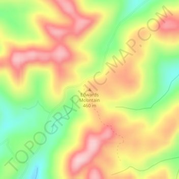
Carte topographique Edwards Mountain
Carte interactive
Cliquez sur la carte pour afficher l’altitude.
À propos de cette carte
Nom : Carte topographique Edwards Mountain, altitude, relief.
Lieu : Edwards Mountain, Wayne County, Kentucky, USA (36.71724 -84.90861 36.71734 -84.90851)
Altitude moyenne : 426 m
Altitude minimum : 312 m
Altitude maximum : 524 m
Autres cartes topographiques
Cliquez sur une carte pour visualiser sa topographie, son altitude et son relief.
Daniel Boone National Forest
Daniel Boone National Forest, Forest Road, Lakes, Jackson County, Kentucky, USA
Altitude moyenne : 341 m
Herrington Lake
USA > Kentucky > Little Needmore
Herrington Lake, Taylor Road, Little Needmore, Boyle County, Kentucky, USA
Altitude moyenne : 261 m
Floyds Fork
USA > Kentucky > Louisville
Floyds Fork, Louisville, Jefferson County, Kentucky, 40023, USA
Altitude moyenne : 191 m
Grayson Lake
Grayson Lake, Horton Flats Road, Bruin, Elliott County, Kentucky, USA
Altitude moyenne : 263 m
General James Taylor Park
General James Taylor Park, Newport, Campbell County, Kentucky, USA
Altitude moyenne : 158 m
Green River Lake
Green River Lake, Hayes Lane, Atchison, Taylor County, Kentucky, USA
Altitude moyenne : 242 m
Powder Mill
USA > Kentucky > Powder Mill
Powder Mill, Hart County, Kentucky, USA
Altitude moyenne : 204 m
Basil Lewis Park
Basil Lewis Park, Latonia, Covington, Kenton County, Kentucky, USA
Altitude moyenne : 163 m
Stringtown
USA > Kentucky > Stringtown
Stringtown, Boone County, Kentucky, 45233, USA
Altitude moyenne : 215 m
Johnsonville
USA > Kentucky > Johnsonville
Johnsonville, Anderson County, Kentucky, USA
Altitude moyenne : 228 m
Henry Mountain
Henry Mountain, Estill County, Kentucky, 40336, USA
Altitude moyenne : 240 m
Fishtrap Lake
Fishtrap Lake, Island Creek Road, Phyllis, Pike County, Kentucky, 41554, USA
Altitude moyenne : 402 m
Abraham Lincoln Birthplace National Historic Site
USA > Kentucky > Boundary Oak
Abraham Lincoln Birthplace National Historic Site, Boundary Oak, Larue County, Kentucky, USA
Altitude moyenne : 238 m
Coxs Creek
USA > Kentucky > Coxs Creek
Coxs Creek, Nelson County, Kentucky, 40013, USA
Altitude moyenne : 197 m
Falling Branch
USA > Kentucky > Falling Branch
Falling Branch, Grayson County, Kentucky, 40119, USA
Altitude moyenne : 171 m
Harrods Creek
USA > Kentucky > Harrods Creek
Harrods Creek, Jefferson County, Kentucky, 40059, USA
Altitude moyenne : 154 m
Cumberland Island
Cumberland Island, Livingston County, Kentucky, USA
Altitude moyenne : 100 m
Reynolds Mountain
Reynolds Mountain, Harlan County, Kentucky, 40863, USA
Altitude moyenne : 685 m
William Whitley House State Shrine
USA > Kentucky > Sugar Grove
William Whitley House State Shrine, Sugar Grove, Lincoln County, Kentucky, USA
Altitude moyenne : 284 m
Beargrass Creek
USA > Kentucky > Louisville
Beargrass Creek, Louisville, Jefferson County, Kentucky, USA
Altitude moyenne : 143 m
Society Hill
Society Hill, Metcalfe County, Kentucky, 42129, USA
Altitude moyenne : 286 m
Mount Morgan
Mount Morgan, Whitley County, Kentucky, 40769, USA
Altitude moyenne : 374 m
White Pine Hollow
White Pine Hollow, Rowan County, Kentucky, USA
Altitude moyenne : 324 m
Raven Run Nature Sanctuary
Raven Run Nature Sanctuary, Lexington, Fayette County, Kentucky, USA
Altitude moyenne : 266 m