
Faire un don
Équipez-vous pour votre prochaine aventure :
En tant que Partenaire Amazon, ce site perçoit une commission sur les achats éligibles sans surcoût pour vous.
Carte topographique Anthem
Cliquez sur la carte pour afficher l’altitude.
Faire un don
Équipez-vous pour votre prochaine aventure :
En tant que Partenaire Amazon, ce site perçoit une commission sur les achats éligibles sans surcoût pour vous.
Anthem
Anthem is built on 5,856 acres (9.2 sq mi) at the base of Daisy Mountain and Gavilan Peak in northern Maricopa County. The CDP portion of Anthem has an area of 7.9 square miles (20 km2). The community's elevation ranges from 1,760 to 2,428 feet (536 to 740 m), with an average elevation of 1,863 feet (568 m). Approximately 36 percent of the community is preserved as open space, including 291 acres (118 ha) of open hillside.
Faire un don
Équipez-vous pour votre prochaine aventure :
En tant que Partenaire Amazon, ce site perçoit une commission sur les achats éligibles sans surcoût pour vous.
À propos de cette carte
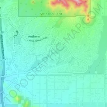
Nom : Carte topographique Anthem, altitude, relief.
Lieu : Anthem, Maricopa County, Arizona, United States (33.82719 -112.14685 33.87839 -112.08250)
Altitude moyenne : 580 m
Altitude minimum : 521 m
Altitude maximum : 856 m
Faire un don
Équipez-vous pour votre prochaine aventure :
En tant que Partenaire Amazon, ce site perçoit une commission sur les achats éligibles sans surcoût pour vous.