
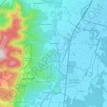
Carte topographique Eguisheim
Carte interactive
Cliquez sur la carte pour afficher l’altitude.
À propos de cette carte
Nom : Carte topographique Eguisheim, altitude, relief.
Altitude moyenne : 282 m
Altitude minimum : 188 m
Altitude maximum : 730 m
Eguisheim s'étend sur 339 hectares et est située à 210 mètres d'altitude. Il s'appuie sur les collines peu pentues et bien exposées au soleil du Schlossberg qui ont permis la plantation de vignes. Eguisheim se trouve à 5 km au sud-ouest de Colmar et peut être rejoint par la route nationale 83 en direction de Rouffach.
Autres cartes topographiques
Cliquez sur une carte pour visualiser sa topographie, son altitude et son relief.
La Cave de Rodern - Schaentzel
France > Grand Est > Haut-Rhin > Rodern
La Cave de Rodern - Schaentzel, Rodern, Colmar-Ribeauvillé, Haut-Rhin, Grand Est, France métropolitaine, 68590, France
Altitude moyenne : 473 m
Masevaux-Niederbruck
France > Grand Est > Haut-Rhin
Masevaux-Niederbruck, Thann-Guebwiller, Haut-Rhin, Grand Est, France métropolitaine, 68290, France
Altitude moyenne : 577 m
Hagenthal-le-Bas
France > Grand Est > Haut-Rhin
Hagenthal-le-Bas, Mulhouse, Haut-Rhin, Grand Est, France métropolitaine, 68220, France
Altitude moyenne : 395 m
Ottmarsheim
France > Grand Est > Haut-Rhin
Ottmarsheim, Mulhouse, Haut-Rhin, Grand Est, France métropolitaine, 68490, France
Altitude moyenne : 224 m
Ampfersbach
France > Grand Est > Haut-Rhin > Stosswihr
Ampfersbach, Stosswihr, Colmar-Ribeauvillé, Haut-Rhin, Grand Est, France métropolitaine, 68140, France
Altitude moyenne : 634 m
Steinbrunn-le-Haut
France > Grand Est > Haut-Rhin
Steinbrunn-le-Haut, Mulhouse, Haut-Rhin, Grand Est, France métropolitaine, 68440, France
Altitude moyenne : 320 m
Volgelsheim
France > Grand Est > Haut-Rhin
Volgelsheim, Colmar-Ribeauvillé, Haut-Rhin, Grand Est, France métropolitaine, 68600, France
Altitude moyenne : 193 m
Sainte-Marie-aux-Mines
France > Grand Est > Haut-Rhin > Sainte-Marie-aux-Mines
Sainte-Marie-aux-Mines, Colmar-Ribeauvillé, Haut-Rhin, Grand Est, France métropolitaine, 68160, France
Altitude moyenne : 713 m
Lapoutroie
France > Grand Est > Haut-Rhin > Lapoutroie
Lapoutroie, Colmar-Ribeauvillé, Haut-Rhin, Grand Est, France métropolitaine, 68650, France
Altitude moyenne : 698 m
Vosges
France > Grand Est > Haut-Rhin > Goldbach-Altenbach
Vosges, Goldbach-Altenbach, Thann-Guebwiller, Haut-Rhin, Grand Est, France métropolitaine, 68760, France
Altitude moyenne : 864 m
Wasserbourg
France > Grand Est > Haut-Rhin > Wasserbourg
Wasserbourg, Colmar-Ribeauvillé, Haut-Rhin, Grand Est, France métropolitaine, 68230, France
Altitude moyenne : 729 m
Katzenthal
France > Grand Est > Haut-Rhin > Katzenthal
Katzenthal, Colmar-Ribeauvillé, Haut-Rhin, Grand Est, France métropolitaine, 68230, France
Altitude moyenne : 293 m
Eschbach-au-Val
France > Grand Est > Haut-Rhin > Eschbach-au-Val
Eschbach-au-Val, Colmar-Ribeauvillé, Haut-Rhin, Grand Est, France métropolitaine, 68140, France
Altitude moyenne : 630 m
Masevaux
France > Grand Est > Haut-Rhin > Masevaux-Niederbruck
Masevaux, Masevaux-Niederbruck, Thann-Guebwiller, Haut-Rhin, Grand Est, France métropolitaine, 68290, France
Altitude moyenne : 577 m
Storckensohn
France > Grand Est > Haut-Rhin > Storckensohn
Storckensohn, Thann-Guebwiller, Haut-Rhin, Grand Est, France métropolitaine, 68470, France
Altitude moyenne : 675 m
Sondernach
France > Grand Est > Haut-Rhin > Sondernach
Sondernach, Colmar-Ribeauvillé, Haut-Rhin, Grand Est, France métropolitaine, 68380, France
Altitude moyenne : 931 m
Ribeauvillé
France > Grand Est > Haut-Rhin > Ribeauvillé
Ribeauvillé, Colmar-Ribeauvillé, Haut-Rhin, Grand Est, France métropolitaine, 68150, France
Altitude moyenne : 395 m
Husseren-les-Châteaux
France > Grand Est > Haut-Rhin > Husseren-les-Châteaux
Husseren-les-Châteaux, Colmar-Ribeauvillé, Haut-Rhin, Grand Est, France métropolitaine, 68420, France
Altitude moyenne : 398 m
Kaysersberg
France > Grand Est > Haut-Rhin > Kaysersberg-Vignoble
Kaysersberg, Kaysersberg-Vignoble, Colmar-Ribeauvillé, Haut-Rhin, Grand Est, France métropolitaine, 68240, France
Altitude moyenne : 523 m
Niedermorschwihr
France > Grand Est > Haut-Rhin
Niedermorschwihr, Colmar-Ribeauvillé, Haut-Rhin, Grand Est, France métropolitaine, 68230, France
Altitude moyenne : 339 m