
Carte topographique Lausanne
Carte interactive
Cliquez sur la carte pour afficher l’altitude.
À propos de cette carte
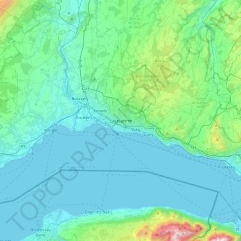
Nom : Carte topographique Lausanne, altitude, relief.
Lieu : Lausanne, District de Lausanne, Vaud, 1003, Switzerland (46.36183 6.47270 46.68183 6.79270)
Altitude moyenne : 577 m
Altitude minimum : 367 m
Altitude maximum : 1.958 m
The most important geographical feature of the area surrounding Lausanne is Lake Geneva (Lac Léman in French). Lausanne is built on the southern slope of the Swiss plateau, with a difference in elevation of about 500 metres (1,640 ft) between the lakeshore at Ouchy and its northern edge bordering Le Mont-sur-Lausanne and Épalinges. Lausanne boasts a dramatic panorama over the lake and the Swiss and Savoyan Alps.