
Faire un don
Équipez-vous pour votre prochaine aventure :
En tant que Partenaire Amazon, ce site perçoit une commission sur les achats éligibles sans surcoût pour vous.
Carte topographique Nilambur
Cliquez sur la carte pour afficher l’altitude.
Faire un don
Équipez-vous pour votre prochaine aventure :
En tant que Partenaire Amazon, ce site perçoit une commission sur les achats éligibles sans surcoût pour vous.
Nilambur
The 2,554 m (8,379 ft) m high Mukurthi peak, which is situated in the border of Nilambur Taluk and Ooty Taluk, and is also the fifth-highest peak in South India as well as the third-highest in Kerala after Anamudi (2,696 m [8,845 ft]) and Meesapulimala (2,651 m [8,698 ft]), is the highest point of elevation in Malappuram district. It is also the highest peak in Kerala outside the Idukki district. The 2,383 m (7,818 ft) high Anginda peak, which is located closer to Malappuram-Palakkad-Nilgiris district border is the second-highest peak. Vavul Mala, a 2,339 m [7,674 ft] high peak situated on the trijunction of Nilambur Taluk of Malappuram, Wayanad, and Thamarassery Taluk of Kozhikode districts, is the third-highest point of elevation in the district. The Nilambur Taluk has several small and medium-sized tributaries of Chaliyar river.
Faire un don
Équipez-vous pour votre prochaine aventure :
En tant que Partenaire Amazon, ce site perçoit une commission sur les achats éligibles sans surcoût pour vous.
À propos de cette carte
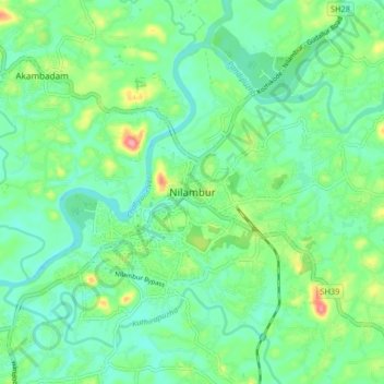
Nom : Carte topographique Nilambur, altitude, relief.
Lieu : Nilambur, Malappuram, Kerala, 679329, India (11.24651 76.20074 11.32651 76.28074)
Altitude moyenne : 33 m
Altitude minimum : 6 m
Altitude maximum : 103 m
Faire un don
Équipez-vous pour votre prochaine aventure :
En tant que Partenaire Amazon, ce site perçoit une commission sur les achats éligibles sans surcoût pour vous.
Autres cartes topographiques
Cliquez sur une carte pour visualiser sa topographie, son altitude et son relief.
Faire un don
Équipez-vous pour votre prochaine aventure :
En tant que Partenaire Amazon, ce site perçoit une commission sur les achats éligibles sans surcoût pour vous.