
Faire un don
Équipez-vous pour votre prochaine aventure :
En tant que Partenaire Amazon, ce site perçoit une commission sur les achats éligibles sans surcoût pour vous.
Carte topographique Bangladesh
Cliquez sur la carte pour afficher l’altitude.
Faire un don
Équipez-vous pour votre prochaine aventure :
En tant que Partenaire Amazon, ce site perçoit une commission sur les achats éligibles sans surcoût pour vous.
Bangladesh
With an elevation of 1,064 m (3,491 ft), Saka Haphong (also known as Mowdok Mual) near the border with Myanmar, is claimed to be the highest peak of Bangladesh. However, it is not yet widely recognized as the highest point of the country, and most sources give the honor to Keokradong.
Faire un don
Équipez-vous pour votre prochaine aventure :
En tant que Partenaire Amazon, ce site perçoit une commission sur les achats éligibles sans surcoût pour vous.
À propos de cette carte
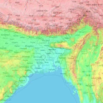
Nom : Carte topographique Bangladesh, altitude, relief.
Lieu : Bangladesh (17.47688 83.29324 31.47688 97.29324)
Altitude moyenne : 1.488 m
Altitude minimum : -3 m
Altitude maximum : 7.813 m
Faire un don
Équipez-vous pour votre prochaine aventure :
En tant que Partenaire Amazon, ce site perçoit une commission sur les achats éligibles sans surcoût pour vous.
Autres cartes topographiques
Cliquez sur une carte pour visualiser sa topographie, son altitude et son relief.
Sylhet Division
The region is considered one of the most picturesque and archaeologically rich regions in South Asia. It is home to three national parks; the Lawachara National Park, Khadim Nagar National Park and Satchari National Park, as well as numerous smaller parks and forests such as the Ratargul Swamp Forest,…
Altitude moyenne : 88 m
Rajeshpur Eco-Park
Bangladesh > Chattogram Division > Cumilla Adarsha Sadar Upazila
Altitude moyenne : 15 m
Faire un don
Équipez-vous pour votre prochaine aventure :
En tant que Partenaire Amazon, ce site perçoit une commission sur les achats éligibles sans surcoût pour vous.