
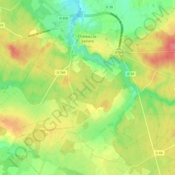
Carte topographique Château-la-Vallière
Carte interactive
Cliquez sur la carte pour afficher l’altitude.
À propos de cette carte
Nom : Carte topographique Château-la-Vallière, altitude, relief.
Altitude moyenne : 96 m
Altitude minimum : 59 m
Altitude maximum : 137 m
Autres cartes topographiques
Cliquez sur une carte pour visualiser sa topographie, son altitude et son relief.
Villeplate
France > Centre-Val de Loire > Indre-et-Loire > La Guerche
Villeplate, La Guerche, Loches, Indre-et-Loire, Centre-Val de Loire, Metropolitan France, 37350, France
Altitude moyenne : 81 m
Saché
France > Centre-Val de Loire > Indre-et-Loire
Saché, Tours, Indre-et-Loire, Centre-Val de Loire, Metropolitan France, 37190, France
Altitude moyenne : 86 m
Larçay
France > Centre-Val de Loire > Indre-et-Loire
Larçay, Tours, Indre-et-Loire, Centre-Val de Loire, Metropolitan France, 37270, France
Altitude moyenne : 81 m
La Boiselle
France > Centre-Val de Loire > Indre-et-Loire > Dierre
La Boiselle, Les Devants du Prieuré, Dierre, Loches, Indre-et-Loire, Centre-Val de Loire, Metropolitan France, 37150, France
Altitude moyenne : 76 m
Le Bourg
France > Centre-Val de Loire > Indre-et-Loire > Cinq-Mars-la-Pile
Le Bourg, Cinq-Mars-la-Pile, Chinon, Indre-et-Loire, Centre-Val de Loire, Metropolitan France, 37130, France
Altitude moyenne : 62 m
Le Bourg
France > Centre-Val de Loire > Indre-et-Loire > Fondettes
Le Bourg, Fondettes, Tours, Indre-et-Loire, Centre-Val de Loire, Metropolitan France, 37230, France
Altitude moyenne : 83 m
Saint-Flovier
France > Centre-Val de Loire > Indre-et-Loire
Saint-Flovier, Loches, Indre-et-Loire, Centre-Val de Loire, Metropolitan France, 37600, France
Altitude moyenne : 135 m
Marcilly-sur-Vienne
France > Centre-Val de Loire > Indre-et-Loire
Marcilly-sur-Vienne, Chinon, Indre-et-Loire, Centre-Val de Loire, Metropolitan France, 37800, France
Altitude moyenne : 62 m
Le Bois Turbet
France > Centre-Val de Loire > Indre-et-Loire > Marcé-sur-Esves
Le Bois Turbet, Marcé-sur-Esves, Loches, Indre-et-Loire, Centre-Val de Loire, Metropolitan France, 37160, France
Altitude moyenne : 82 m
La Bérangerie
France > Centre-Val de Loire > Indre-et-Loire > Saint-Jean-Saint-Germain
La Bérangerie, Saint-Jean-Saint-Germain, Loches, Indre-et-Loire, Centre-Val de Loire, Metropolitan France, 37600, France
Altitude moyenne : 108 m
Descartes
France > Centre-Val de Loire > Indre-et-Loire
Descartes, Loches, Indre-et-Loire, Centre-Val de Loire, Metropolitan France, 37160, France
Altitude moyenne : 90 m
Tours
France > Centre-Val de Loire > Indre-et-Loire
Tours, Indre-et-Loire, Centre-Val de Loire, Metropolitan France, France
Altitude moyenne : 73 m
Chinon
France > Centre-Val de Loire > Indre-et-Loire
Chinon, Indre-et-Loire, Centre-Val de Loire, Metropolitan France, 37500, France
Altitude moyenne : 58 m
Amboise
France > Centre-Val de Loire > Indre-et-Loire
Amboise, Loches, Indre-et-Loire, Centre-Val de Loire, Metropolitan France, 37400, France
Altitude moyenne : 91 m
Ciran
France > Centre-Val de Loire > Indre-et-Loire
Ciran, Loches, Indre-et-Loire, Centre-Val de Loire, Metropolitan France, 37240, France
Altitude moyenne : 103 m
Varton
France > Centre-Val de Loire > Indre-et-Loire > Boussay
Varton, Boussay, Loches, Indre-et-Loire, Centre-Val de Loire, Metropolitan France, 37290, France
Altitude moyenne : 109 m