
Faire un don
Équipez-vous pour votre prochaine aventure :
En tant que Partenaire Amazon, ce site perçoit une commission sur les achats éligibles sans surcoût pour vous.
Carte topographique Moselle
Cliquez sur la carte pour afficher l’altitude.
Faire un don
Équipez-vous pour votre prochaine aventure :
En tant que Partenaire Amazon, ce site perçoit une commission sur les achats éligibles sans surcoût pour vous.
Moselle
Dans sa partie occidentale, le paysage est celui d'un plateau avec un mélange de terres agricoles et de collines boisées de faible altitude. Dans la partie orientale, le paysage est progressivement marqué par la forêt et un caractère plus montagnard, en tant que partie mosellane du massif des Vosges et des Vosges du Nord. Le point culminant de la Moselle est le Grossmann (986 m)
Faire un don
Équipez-vous pour votre prochaine aventure :
En tant que Partenaire Amazon, ce site perçoit une commission sur les achats éligibles sans surcoût pour vous.
À propos de cette carte
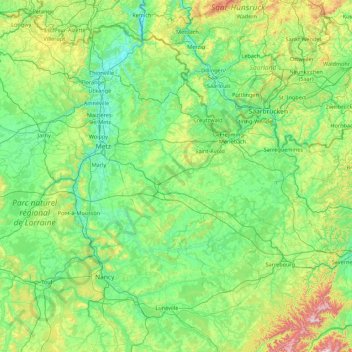
Nom : Carte topographique Moselle, altitude, relief.
Lieu : Moselle, Grand Est, France métropolitaine, France (48.52656 5.89185 49.51494 7.63882)
Altitude moyenne : 289 m
Altitude minimum : 141 m
Altitude maximum : 1.017 m
Faire un don
Équipez-vous pour votre prochaine aventure :
En tant que Partenaire Amazon, ce site perçoit une commission sur les achats éligibles sans surcoût pour vous.
Autres cartes topographiques
Cliquez sur une carte pour visualiser sa topographie, son altitude et son relief.
Troyes
France > Grand Est > Aube > Troyes
La superficie de la commune de Troyes est de 1 320 ha quand la superficie moyenne communale en France métropolitaine s'établit à 1 505,8 ha ; son altitude varie de 100 m, au niveau de la Seine à la limite entre Troyes et Barberey-Saint-Sulpice, à 126 m au sud-ouest, à la limite du territoire communal de…
Altitude moyenne : 151 m
Faire un don
Équipez-vous pour votre prochaine aventure :
En tant que Partenaire Amazon, ce site perçoit une commission sur les achats éligibles sans surcoût pour vous.
Faire un don
Équipez-vous pour votre prochaine aventure :
En tant que Partenaire Amazon, ce site perçoit une commission sur les achats éligibles sans surcoût pour vous.
Château du Haut-Kœnigsbourg
France > Grand Est > Bas-Rhin > Orschwiller
Le château est situé dans le massif des Vosges à une altitude de 757 m à 12 km à l'ouest de Sélestat d'où il est visible. Il se trouve également à 26 km au nord de Colmar d'où il est également visible par temps clair et à 55 km au sud de Strasbourg.
Altitude moyenne : 441 m
Faire un don
Équipez-vous pour votre prochaine aventure :
En tant que Partenaire Amazon, ce site perçoit une commission sur les achats éligibles sans surcoût pour vous.
Réserve biologique dirigée des Vallons de Gorze
France > Grand Est > Moselle > Gorze > Saint-Thiébaut
Altitude moyenne : 272 m
Faire un don
Équipez-vous pour votre prochaine aventure :
En tant que Partenaire Amazon, ce site perçoit une commission sur les achats éligibles sans surcoût pour vous.
Faire un don
Équipez-vous pour votre prochaine aventure :
En tant que Partenaire Amazon, ce site perçoit une commission sur les achats éligibles sans surcoût pour vous.
Faire un don
Équipez-vous pour votre prochaine aventure :
En tant que Partenaire Amazon, ce site perçoit une commission sur les achats éligibles sans surcoût pour vous.
Faire un don
Équipez-vous pour votre prochaine aventure :
En tant que Partenaire Amazon, ce site perçoit une commission sur les achats éligibles sans surcoût pour vous.
Faire un don
Équipez-vous pour votre prochaine aventure :
En tant que Partenaire Amazon, ce site perçoit une commission sur les achats éligibles sans surcoût pour vous.
Faire un don
Équipez-vous pour votre prochaine aventure :
En tant que Partenaire Amazon, ce site perçoit une commission sur les achats éligibles sans surcoût pour vous.
Faire un don
Équipez-vous pour votre prochaine aventure :
En tant que Partenaire Amazon, ce site perçoit une commission sur les achats éligibles sans surcoût pour vous.
Réserve biologique dirigée de Faux de Verzy
France > Grand Est > Marne > Verzy
Altitude moyenne : 248 m
Faire un don
Équipez-vous pour votre prochaine aventure :
En tant que Partenaire Amazon, ce site perçoit une commission sur les achats éligibles sans surcoût pour vous.
Faire un don
Équipez-vous pour votre prochaine aventure :
En tant que Partenaire Amazon, ce site perçoit une commission sur les achats éligibles sans surcoût pour vous.
Faire un don
Équipez-vous pour votre prochaine aventure :
En tant que Partenaire Amazon, ce site perçoit une commission sur les achats éligibles sans surcoût pour vous.
Faire un don
Équipez-vous pour votre prochaine aventure :
En tant que Partenaire Amazon, ce site perçoit une commission sur les achats éligibles sans surcoût pour vous.
Lac du Forlet
France > Grand Est > Haut-Rhin > Soultzeren
Le lac des Truites, ou lac du Forlet, est le plus élevé des lacs vosgiens à 1 066 m d'altitude. Il est dénommé Forlenweier en alsacien et reïf tou blan en welsch.
Altitude moyenne : 1.134 m
Col du Grand Ballon
France > Grand Est > Haut-Rhin > Soultz-Haut-Rhin
La route des Crêtes contourne le sommet par l'est, franchissant un col à l'altitude de 1 341 mètres, entre le Markstein et le Hartmannswillerkopf (Vieil Armand).
Altitude moyenne : 1.143 m
Faire un don
Équipez-vous pour votre prochaine aventure :
En tant que Partenaire Amazon, ce site perçoit une commission sur les achats éligibles sans surcoût pour vous.
Col de la Schlucht
France > Grand Est > Vosges > Le Valtin > La Schlucht
Situé à une altitude de 1 139 mètres, le col de la Schlucht fait communiquer les vallées lorraines de la Meurthe et de la Vologne avec la vallée alsacienne de la Fecht, un affluent de l'Ill. Les sources de la Meurthe et de la Fecht sont voisines du col de la Schlucht. La première coule sur les hauteurs…
Altitude moyenne : 1.068 m
Faire un don
Équipez-vous pour votre prochaine aventure :
En tant que Partenaire Amazon, ce site perçoit une commission sur les achats éligibles sans surcoût pour vous.
Faire un don
Équipez-vous pour votre prochaine aventure :
En tant que Partenaire Amazon, ce site perçoit une commission sur les achats éligibles sans surcoût pour vous.
Plateau de Malzéville
France > Grand Est > Dommartemont
D'une surface de 557 hectares (plateau et butte Sainte Geneviève), le plateau, majoritairement boisé de résineux, est classé site d'importance communautaire. Sa surface classée Natura 2000 représente 439 ha. Il culmine à 384 mètres d'altitude.
Altitude moyenne : 314 m
Ballon d'Alsace
France > Grand Est > Haut-Rhin > Sewen
Le ballon d'Alsace, qui culmine à 1 247 mètres d'altitude, est l'un des premiers sommets significatifs lorsqu'on aborde le massif des Vosges par le sud. Il offre ainsi un large panorama, la Forêt-Noire à l'est, le Jura, la trouée de Belfort et, par temps clair, la chaîne des Alpes bernoises et le mont…
Altitude moyenne : 994 m
Faire un don
Équipez-vous pour votre prochaine aventure :
En tant que Partenaire Amazon, ce site perçoit une commission sur les achats éligibles sans surcoût pour vous.
Vosges
France > Grand Est > Goldbach-Altenbach
Les Vosges sont un massif de moyennes montagnes du Nord-Est de la France qui sépare le plateau lorrain de la plaine d'Alsace. D'origine varisque et majoritairement constituées de grès et de granite, elles atteignent des altitudes modestes culminant à 1 424 mètres au Grand Ballon.
Altitude moyenne : 864 m
Faire un don
Équipez-vous pour votre prochaine aventure :
En tant que Partenaire Amazon, ce site perçoit une commission sur les achats éligibles sans surcoût pour vous.
Faire un don
Équipez-vous pour votre prochaine aventure :
En tant que Partenaire Amazon, ce site perçoit une commission sur les achats éligibles sans surcoût pour vous.
Faire un don
Équipez-vous pour votre prochaine aventure :
En tant que Partenaire Amazon, ce site perçoit une commission sur les achats éligibles sans surcoût pour vous.
Faire un don
Équipez-vous pour votre prochaine aventure :
En tant que Partenaire Amazon, ce site perçoit une commission sur les achats éligibles sans surcoût pour vous.
Faire un don
Équipez-vous pour votre prochaine aventure :
En tant que Partenaire Amazon, ce site perçoit une commission sur les achats éligibles sans surcoût pour vous.
Faire un don
Équipez-vous pour votre prochaine aventure :
En tant que Partenaire Amazon, ce site perçoit une commission sur les achats éligibles sans surcoût pour vous.
Col du Pfaffenschlick
France > Grand Est > Bas-Rhin > Climbach > Col du Pfaffenschlick
Le col du Pfaffenschlick se situe dans les Vosges du Nord, dans le département français du Bas-Rhin, au carrefour des RD 51 et 65 entre Climbach et Lobsann d'une part, et Lembach et Schœnenbourg d'autre part. La route franchit le massif du Hochwald et passe à une altitude de 371 mètres.
Altitude moyenne : 353 m
Faire un don
Équipez-vous pour votre prochaine aventure :
En tant que Partenaire Amazon, ce site perçoit une commission sur les achats éligibles sans surcoût pour vous.