
Faire un don
Équipez-vous pour votre prochaine aventure :
En tant que Partenaire Amazon, ce site perçoit une commission sur les achats éligibles sans surcoût pour vous.
Carte topographique Danbury
Cliquez sur la carte pour afficher l’altitude.
Faire un don
Équipez-vous pour votre prochaine aventure :
En tant que Partenaire Amazon, ce site perçoit une commission sur les achats éligibles sans surcoût pour vous.
Danbury
The highest point in Danbury is the summit of Tinkham Hill, at 2,320 feet (710 m) above sea level, in the northern part of town. Ragged Mountain is a prominent mountain with multiple summits which occupies the southern portion of town and has a ski area of the same name; the elevation of the Danbury summit of Ragged is 2,225 ft (678 m) above sea level. The Sunapee-Ragged-Kearsarge Greenway hiking trail crosses a corner of Danbury along Ragged Mountain's Ridge Trail. Access to the Ridge Trail from the SRK Greenway is on the SRKG 6.1 mile trail section 9, either from trailhead parking on New Canada Road in Wilmot from the northwest or from Proctor Academy's trailhead parking in Andover from the southeast.
Faire un don
Équipez-vous pour votre prochaine aventure :
En tant que Partenaire Amazon, ce site perçoit une commission sur les achats éligibles sans surcoût pour vous.
À propos de cette carte
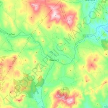
Nom : Carte topographique Danbury, altitude, relief.
Altitude moyenne : 349 m
Altitude minimum : 138 m
Altitude maximum : 700 m
Faire un don
Équipez-vous pour votre prochaine aventure :
En tant que Partenaire Amazon, ce site perçoit une commission sur les achats éligibles sans surcoût pour vous.
Autres cartes topographiques
Cliquez sur une carte pour visualiser sa topographie, son altitude et son relief.
Faire un don
Équipez-vous pour votre prochaine aventure :
En tant que Partenaire Amazon, ce site perçoit une commission sur les achats éligibles sans surcoût pour vous.
Catamount Mountain
United States > New Hampshire > Merrimack County > Pittsfield
Altitude moyenne : 281 m
Faire un don
Équipez-vous pour votre prochaine aventure :
En tant que Partenaire Amazon, ce site perçoit une commission sur les achats éligibles sans surcoût pour vous.
Faire un don
Équipez-vous pour votre prochaine aventure :
En tant que Partenaire Amazon, ce site perçoit une commission sur les achats éligibles sans surcoût pour vous.
Faire un don
Équipez-vous pour votre prochaine aventure :
En tant que Partenaire Amazon, ce site perçoit une commission sur les achats éligibles sans surcoût pour vous.
Rings Corner
United States > New Hampshire > Merrimack County > Pittsfield > Rings Corner
Altitude moyenne : 190 m
Faire un don
Équipez-vous pour votre prochaine aventure :
En tant que Partenaire Amazon, ce site perçoit une commission sur les achats éligibles sans surcoût pour vous.