
Faire un don
Équipez-vous pour votre prochaine aventure :
En tant que Partenaire Amazon, ce site perçoit une commission sur les achats éligibles sans surcoût pour vous.
Carte topographique Cromwell Community
Cliquez sur la carte pour afficher l’altitude.
Faire un don
Équipez-vous pour votre prochaine aventure :
En tant que Partenaire Amazon, ce site perçoit une commission sur les achats éligibles sans surcoût pour vous.
À propos de cette carte
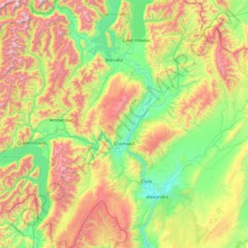
Nom : Carte topographique Cromwell Community, altitude, relief.
Altitude moyenne : 876 m
Altitude minimum : 133 m
Altitude maximum : 2.593 m
Faire un don
Équipez-vous pour votre prochaine aventure :
En tant que Partenaire Amazon, ce site perçoit une commission sur les achats éligibles sans surcoût pour vous.
Autres cartes topographiques
Cliquez sur une carte pour visualiser sa topographie, son altitude et son relief.
Naseby
New Zealand > Otago > Central Otago District > Maniototo Community
Naseby is a small town in the Maniototo region of Central Otago, New Zealand. The town catch phrase is "2000 feet above worry level" indicating its altitude. The town is 140 km (90 mi) from Dunedin. The centre of the town is a registered historic area, and there are many heritage buildings. Naseby has hot…
Altitude moyenne : 619 m
Bannockburn
New Zealand > Otago > Central Otago District > Cromwell Community
Altitude moyenne : 279 m
Ranfurly
New Zealand > Otago > Central Otago District
Ranfurly is a town in the Central Otago District of Otago, New Zealand. Located 110 kilometres (68 miles) north of Dunedin, it lies in the dry rough plain of Maniototo at a moderately high altitude (around 430 metres or 1,410 feet above sea level) close to a small tributary of the Taieri River. It operates as…
Altitude moyenne : 428 m
Ettrick
New Zealand > Otago > Central Otago District > Teviot Valley Community
Altitude moyenne : 105 m
Faire un don
Équipez-vous pour votre prochaine aventure :
En tant que Partenaire Amazon, ce site perçoit une commission sur les achats éligibles sans surcoût pour vous.
Mount Kāmaka
New Zealand > Otago > Central Otago District > Cromwell Community
Altitude moyenne : 905 m
Clyde Dam
New Zealand > Otago > Central Otago District > Vincent Community > Clyde
Altitude moyenne : 318 m
Bannockburn
New Zealand > Otago > Central Otago District > Cromwell Community
Altitude moyenne : 279 m
Faire un don
Équipez-vous pour votre prochaine aventure :
En tant que Partenaire Amazon, ce site perçoit une commission sur les achats éligibles sans surcoût pour vous.
Central Otago
New Zealand > Otago > Central Otago District > Vincent Community
Altitude moyenne : 935 m
Cromwell
New Zealand > Otago > Central Otago District > Cromwell Community > Cromwell
Altitude moyenne : 330 m
Faire un don
Équipez-vous pour votre prochaine aventure :
En tant que Partenaire Amazon, ce site perçoit une commission sur les achats éligibles sans surcoût pour vous.