
Carte topographique Góis
Carte interactive
Cliquez sur la carte pour afficher l’altitude.
À propos de cette carte
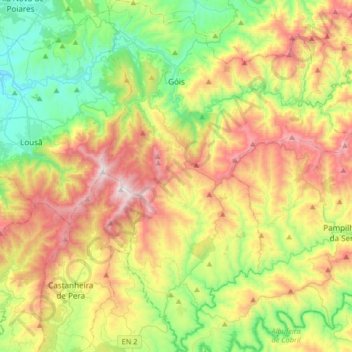
Nom : Carte topographique Góis, altitude, relief.
Lieu : Góis, Coimbra, Portugal (39.96023 -8.18039 40.21286 -7.94867)
Altitude moyenne : 515 m
Altitude minimum : 68 m
Altitude maximum : 1.199 m
The mountains of the Penedo de Góis, which are part of the Serra da Lousã (Lousã Mountains), at a height of 1,043 metres (3,422 ft), have an accentuated orography with many climatic differences; the Lousã represents the end of the southwest-central cordillera, with elevations between 800 metres (2,600 ft) and 1,200 metres (3,900 ft) above sea level, with accentuated slopes (resulting in steep cliffs that are mostly inaccessible) on the northern flanks and gentle in the south influenced by Atlantic and Mediterranean weather systems.
Autres cartes topographiques
Cliquez sur une carte pour visualiser sa topographie, son altitude et son relief.