
Carte topographique Sanger
Carte interactive
Cliquez sur la carte pour afficher l’altitude.
À propos de cette carte
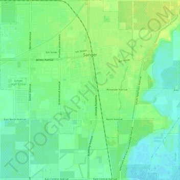
Nom : Carte topographique Sanger, altitude, relief.
Altitude moyenne : 111 m
Altitude minimum : 102 m
Altitude maximum : 120 m
Sanger is a city in Fresno County, California, United States. The population was 24,270 at the 2010 census, up from 18,731 at the 2000 census. Sanger is located 13 miles (21 km) east-southeast of Fresno, at an elevation of 371 feet (113 m).