
Carte topographique Troyes
Carte interactive
Cliquez sur la carte pour afficher l’altitude.
À propos de cette carte
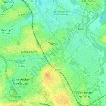
Nom : Carte topographique Troyes, altitude, relief.
Lieu : Troyes, Aube, Grand Est, France métropolitaine, 10000, France (48.26632 4.04117 48.31859 4.11114)
Altitude moyenne : 112 m
Altitude minimum : 100 m
Altitude maximum : 132 m
La superficie de la commune de Troyes est de 1 320 ha quand la superficie moyenne communale en France métropolitaine s'établit à 1 505,8 ha ; son altitude varie de 100 m, au niveau de la Seine à la limite entre Troyes et Barberey-Saint-Sulpice, à 126 m au sud-ouest, à la limite du territoire communal de Saint-André-les-Vergers.
Autres cartes topographiques
Cliquez sur une carte pour visualiser sa topographie, son altitude et son relief.
Rue du Moulin
France > Grand Est > Aube > Argançon
Rue du Moulin, Argançon, Bar-sur-Aube, Aube, Grand Est, France métropolitaine, 10140, France
Altitude moyenne : 215 m
Saint-Nicolas-la-Chapelle
Saint-Nicolas-la-Chapelle, Nogent-sur-Seine, Aube, Grand Est, France métropolitaine, 10400, France
Altitude moyenne : 91 m
Voie des Brebis
France > Grand Est > Aube > Cussangy
Voie des Brebis, Cussangy, Troyes, Aube, Grand Est, France métropolitaine, 10210, France
Altitude moyenne : 187 m
Rigny-le-Ferron
Rigny-le-Ferron, Troyes, Aube, Grand Est, France métropolitaine, 10160, France
Altitude moyenne : 168 m
Arrentières
Arrentières, Bar-sur-Aube, Aube, Grand Est, France métropolitaine, 10200, France
Altitude moyenne : 268 m
Le Village
France > Grand Est > Aube > Fouchères
Le Village, Fouchères, Troyes, Aube, Grand Est, France métropolitaine, 10260, France
Altitude moyenne : 151 m
Mesnil-Saint-Père
Mesnil-Saint-Père, Troyes, Aube, Grand Est, France métropolitaine, 10140, France
Altitude moyenne : 140 m
Lusigny-sur-Barse
Lusigny-sur-Barse, Troyes, Aube, Grand Est, France métropolitaine, 10270, France
Altitude moyenne : 128 m
Landreville
France > Grand Est > Aube > Landreville > Landreville
Landreville, Troyes, Aube, Grand Est, France métropolitaine, 10110, France
Altitude moyenne : 219 m
Nogent-sur-Seine
Nogent-sur-Seine, Aube, Grand Est, France métropolitaine, 10400, France
Altitude moyenne : 73 m
Mailly-le-Camp
Mailly-le-Camp, Troyes, Aube, Grand Est, France métropolitaine, 10230, France
Altitude moyenne : 153 m
Landreville
Landreville, Troyes, Aube, Grand Est, France métropolitaine, 10110, France
Altitude moyenne : 232 m