
Faire un don
Équipez-vous pour votre prochaine aventure :
En tant que Partenaire Amazon, ce site perçoit une commission sur les achats éligibles sans surcoût pour vous.
Carte topographique Boone
Cliquez sur la carte pour afficher l’altitude.
Faire un don
Équipez-vous pour votre prochaine aventure :
En tant que Partenaire Amazon, ce site perçoit une commission sur les achats éligibles sans surcoût pour vous.
À propos de cette carte
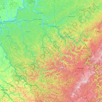
Nom : Carte topographique Boone, altitude, relief.
Lieu : Boone, West Virginia, 25092, United States (37.30933 -82.40136 38.70933 -81.00136)
Altitude moyenne : 431 m
Altitude minimum : 159 m
Altitude maximum : 1.070 m
Faire un don
Équipez-vous pour votre prochaine aventure :
En tant que Partenaire Amazon, ce site perçoit une commission sur les achats éligibles sans surcoût pour vous.
Autres cartes topographiques
Cliquez sur une carte pour visualiser sa topographie, son altitude et son relief.
Morgantown
United States > West Virginia > Monongalia County
During the 1970s, the U.S. Department of Transportation built an experimental driverless personal rapid transit system in the city, citing the area's variable seasonal climate and geographic elevations as factors in testing the technology's viability. The Morgantown Personal Rapid Transit (PRT) has been in use…
Altitude moyenne : 335 m
Harpers Ferry
United States > West Virginia > Jefferson County
The town was "easy to seize, and hard to hold", because of its topography: surrounded on three sides by high ground – Bolivar Heights to the west, Loudoun Heights to the south, and Maryland Heights to the east – and surrounded by the Potomac and Shenandoah Rivers, anyone who controlled the heights…
Altitude moyenne : 174 m
Charleston
United States > West Virginia > Kanawha County
Charleston has a four-season humid subtropical climate (Köppen Cfa) with continental climate (Dfa) elements. Especially in winter, Charleston's average temperatures are warmer than the rest of the state, due to the city being west of the higher elevations. Spring is the most unpredictable season, and…
Altitude moyenne : 264 m
Beckley
United States > West Virginia > Raleigh County
Due to its elevation, the climate of Beckley is humid subtropical (Köppen Cfa) bordering on both an oceanic (Köppen Cfb) and humid continental (Köppen Dfa/Dfb), and the city straddles the border between USDA Plant Hardiness Zones 6B and 7A. Summers are warm and humid, usually a few degrees cooler than…
Altitude moyenne : 723 m
Faire un don
Équipez-vous pour votre prochaine aventure :
En tant que Partenaire Amazon, ce site perçoit une commission sur les achats éligibles sans surcoût pour vous.
Morgantown
United States > West Virginia > Monongalia County
During the 1970s, the U.S. Department of Transportation built an experimental driverless personal rapid transit system in the city, citing the area's variable seasonal climate and geographic elevations as factors in testing the technology's viability. The Morgantown Personal Rapid Transit (PRT) has been in use…
Altitude moyenne : 335 m
Faire un don
Équipez-vous pour votre prochaine aventure :
En tant que Partenaire Amazon, ce site perçoit une commission sur les achats éligibles sans surcoût pour vous.
Upshur County
According to the United States Census Bureau, the county has a total area of 355 square miles (920 km2), of which 354.9 square miles (919 km2) is land and 0.1 square miles (0.26 km2) (0.03%) is water. The county falls within the United States National Radio Quiet Zone. The highest elevation in Upshur County is…
Altitude moyenne : 553 m
Faire un don
Équipez-vous pour votre prochaine aventure :
En tant que Partenaire Amazon, ce site perçoit une commission sur les achats éligibles sans surcoût pour vous.
Faire un don
Équipez-vous pour votre prochaine aventure :
En tant que Partenaire Amazon, ce site perçoit une commission sur les achats éligibles sans surcoût pour vous.
Faire un don
Équipez-vous pour votre prochaine aventure :
En tant que Partenaire Amazon, ce site perçoit une commission sur les achats éligibles sans surcoût pour vous.
McDowell County
McDowell County is the southernmost county in West Virginia. It is bordered by Tazewell County, Virginia, to the south; Buchanan County, Virginia, to the west; Mingo County to the northwest; Wyoming County to the north; and Mercer County to the east. The county is located in the Cumberland Mountains, a…
Altitude moyenne : 637 m
Faire un don
Équipez-vous pour votre prochaine aventure :
En tant que Partenaire Amazon, ce site perçoit une commission sur les achats éligibles sans surcoût pour vous.
Faire un don
Équipez-vous pour votre prochaine aventure :
En tant que Partenaire Amazon, ce site perçoit une commission sur les achats éligibles sans surcoût pour vous.
Pocahontas County
According to the United States Census Bureau, the county has a total area of 942 square miles (2,440 km2), of which 940 square miles (2,400 km2) is land and 1.5 square miles (3.9 km2) (0.2%) is water. It is the third-largest county in West Virginia by area, and with a mean altitude of 3,219 feet or 981 metres…
Altitude moyenne : 920 m
Faire un don
Équipez-vous pour votre prochaine aventure :
En tant que Partenaire Amazon, ce site perçoit une commission sur les achats éligibles sans surcoût pour vous.
Faire un don
Équipez-vous pour votre prochaine aventure :
En tant que Partenaire Amazon, ce site perçoit une commission sur les achats éligibles sans surcoût pour vous.
Faire un don
Équipez-vous pour votre prochaine aventure :
En tant que Partenaire Amazon, ce site perçoit une commission sur les achats éligibles sans surcoût pour vous.
Faire un don
Équipez-vous pour votre prochaine aventure :
En tant que Partenaire Amazon, ce site perçoit une commission sur les achats éligibles sans surcoût pour vous.
Faire un don
Équipez-vous pour votre prochaine aventure :
En tant que Partenaire Amazon, ce site perçoit une commission sur les achats éligibles sans surcoût pour vous.
Pendleton County
Spruce Knob, located in Pendleton County, is the highest point in the state and in the Alleghenies, its elevation being 4,863 feet. Parts of the Monongahela and George Washington National Forests are also located in Pendleton County.
Altitude moyenne : 816 m
Faire un don
Équipez-vous pour votre prochaine aventure :
En tant que Partenaire Amazon, ce site perçoit une commission sur les achats éligibles sans surcoût pour vous.
Faire un don
Équipez-vous pour votre prochaine aventure :
En tant que Partenaire Amazon, ce site perçoit une commission sur les achats éligibles sans surcoût pour vous.
Hancock County
According to the United States Census Bureau, the county has a total area of 88 square miles (230 km2), of which 83 square miles (210 km2) is land and 5.4 square miles (14 km2) (6.1%) is water. It is the smallest county in West Virginia by area, as well as one of the smallest in the United States. The highest…
Altitude moyenne : 327 m
Brooke County
According to the United States Census Bureau, the county has a total area of 93 square miles (240 km2), of which 89 square miles (230 km2) is land and 3.4 square miles (8.8 km2) (3.6%) is water. It is the second-smallest county in West Virginia by area. The highest point of elevation in Brooke County is…
Altitude moyenne : 320 m
Ohio County
According to the United States Census Bureau, the county has a total area of 109 square miles (280 km2), of which 106 square miles (270 km2) is land and 3.2 square miles (8.3 km2) (2.9%) is water. It is the third-smallest county in West Virginia by area. The highest point of elevation in Ohio County is…
Altitude moyenne : 333 m
Faire un don
Équipez-vous pour votre prochaine aventure :
En tant que Partenaire Amazon, ce site perçoit une commission sur les achats éligibles sans surcoût pour vous.
Faire un don
Équipez-vous pour votre prochaine aventure :
En tant que Partenaire Amazon, ce site perçoit une commission sur les achats éligibles sans surcoût pour vous.
Charleston
United States > West Virginia > Kanawha County
Charleston has a four-season humid subtropical climate (Köppen Cfa) with continental climate (Dfa) elements. Especially in winter, Charleston's average temperatures are warmer than the rest of the state, due to the city being west of the higher elevations. Spring is the most unpredictable season, and…
Altitude moyenne : 264 m
Faire un don
Équipez-vous pour votre prochaine aventure :
En tant que Partenaire Amazon, ce site perçoit une commission sur les achats éligibles sans surcoût pour vous.
Charles Town
United States > West Virginia > Jefferson County
Due to its low elevation for West Virginia, Charles Town is on the northern extent of the Humid Subtropical climate zone, having cool to mildly cold winters and hot and humid summers. Precipitation is evenly distributed throughout the year, providing lush, abundant plant growth.
Altitude moyenne : 150 m
Faire un don
Équipez-vous pour votre prochaine aventure :
En tant que Partenaire Amazon, ce site perçoit une commission sur les achats éligibles sans surcoût pour vous.
Greenville
United States > West Virginia > Logan County > Greenville > Hensley Heights
Altitude moyenne : 371 m
Faire un don
Équipez-vous pour votre prochaine aventure :
En tant que Partenaire Amazon, ce site perçoit une commission sur les achats éligibles sans surcoût pour vous.
Canaan Valley Resort State Park
United States > West Virginia > Tucker County
Altitude moyenne : 1.033 m
Faire un don
Équipez-vous pour votre prochaine aventure :
En tant que Partenaire Amazon, ce site perçoit une commission sur les achats éligibles sans surcoût pour vous.
Harpers Ferry
United States > West Virginia > Jefferson County
The town was "easy to seize, and hard to hold", because of its topography: surrounded on three sides by high ground (Bolivar Heights to the west, Loudoun Heights to the south, and Maryland Heights to the east) and the Potomac and Shenandoah Rivers, anyone who controlled the heights controlled the city.
Altitude moyenne : 174 m
Faire un don
Équipez-vous pour votre prochaine aventure :
En tant que Partenaire Amazon, ce site perçoit une commission sur les achats éligibles sans surcoût pour vous.
New River Gorge National Park
United States > West Virginia > Fayette County > Fayetteville
Altitude moyenne : 655 m
Faire un don
Équipez-vous pour votre prochaine aventure :
En tant que Partenaire Amazon, ce site perçoit une commission sur les achats éligibles sans surcoût pour vous.
Elkins
United States > West Virginia > Randolph County
Elkins is located at the confluence of the Tygart Valley River and Leading Creek. The average elevation is 2,000 feet (610 m) above sea level. According to the United States Census Bureau, the city has a total area of 3.43 square miles (8.88 km2), all land. Elkins is headquarters for the Monongahela National…
Altitude moyenne : 637 m
Upshur County
According to the United States Census Bureau, the county has a total area of 355 square miles (920 km2), of which 354.9 square miles (919 km2) is land and 0.1 square miles (0.26 km2) (0.03%) is water. The county falls within the United States National Radio Quiet Zone. The highest elevation in Upshur County is…
Altitude moyenne : 553 m
Faire un don
Équipez-vous pour votre prochaine aventure :
En tant que Partenaire Amazon, ce site perçoit une commission sur les achats éligibles sans surcoût pour vous.
Faire un don
Équipez-vous pour votre prochaine aventure :
En tant que Partenaire Amazon, ce site perçoit une commission sur les achats éligibles sans surcoût pour vous.
Faire un don
Équipez-vous pour votre prochaine aventure :
En tant que Partenaire Amazon, ce site perçoit une commission sur les achats éligibles sans surcoût pour vous.