
Faire un don
Équipez-vous pour votre prochaine aventure :
En tant que Partenaire Amazon, ce site perçoit une commission sur les achats éligibles sans surcoût pour vous.
Carte topographique Oyama
Cliquez sur la carte pour afficher l’altitude.
Faire un don
Équipez-vous pour votre prochaine aventure :
En tant que Partenaire Amazon, ce site perçoit une commission sur les achats éligibles sans surcoût pour vous.
Oyama
Oyama is located in the far northeastern corner of Shizuoka Prefecture, bordering on Yamanashi and Kanagawa Prefectures. Located in between the Tanzawa Mountains and the foothills of Mount Fuji, the town has an average altitude of 800 meters, and has a cool climate with heavy rainfall. Some 65% of the town is covered in forest.
Faire un don
Équipez-vous pour votre prochaine aventure :
En tant que Partenaire Amazon, ce site perçoit une commission sur les achats éligibles sans surcoût pour vous.
À propos de cette carte
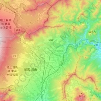
Nom : Carte topographique Oyama, altitude, relief.
Altitude moyenne : 737 m
Altitude minimum : 95 m
Altitude maximum : 1.722 m
Faire un don
Équipez-vous pour votre prochaine aventure :
En tant que Partenaire Amazon, ce site perçoit une commission sur les achats éligibles sans surcoût pour vous.