
Faire un don
Équipez-vous pour votre prochaine aventure :
En tant que Partenaire Amazon, ce site perçoit une commission sur les achats éligibles sans surcoût pour vous.
Carte topographique Macuto
Cliquez sur la carte pour afficher l’altitude.
Faire un don
Équipez-vous pour votre prochaine aventure :
En tant que Partenaire Amazon, ce site perçoit une commission sur les achats éligibles sans surcoût pour vous.
À propos de cette carte
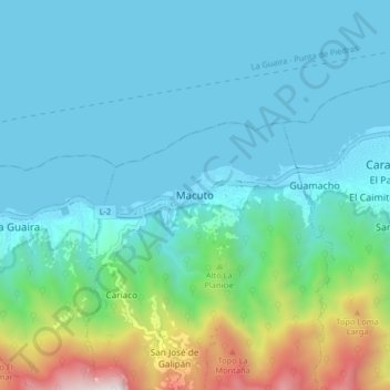
Nom : Carte topographique Macuto, altitude, relief.
Lieu : Macuto, Vargas State, 1164, Venezuela (10.56647 -66.93229 10.64647 -66.85229)
Altitude moyenne : 311 m
Altitude minimum : -2 m
Altitude maximum : 1.715 m
Faire un don
Équipez-vous pour votre prochaine aventure :
En tant que Partenaire Amazon, ce site perçoit une commission sur les achats éligibles sans surcoût pour vous.
Autres cartes topographiques
Cliquez sur une carte pour visualiser sa topographie, son altitude et son relief.
Caracas
Venezuela > Capital District > Municipio Libertador
Caracas is contained entirely within a valley of the Venezuelan Central Range, and is separated from the Caribbean coast by a roughly 15-kilometer (9 mi) expanse of El Ávila National Park. The valley is relatively small and quite irregular, and the altitude varies from between 870 and 1,043 meters (2,854 and…
Altitude moyenne : 759 m
Faire un don
Équipez-vous pour votre prochaine aventure :
En tant que Partenaire Amazon, ce site perçoit une commission sur les achats éligibles sans surcoût pour vous.
Barquisimeto
Venezuela > Lara State > Municipio Iribarren
Barquisimeto is built on the terrace of the same name, on the banks of the Turbio River, about 600 meters (~2000 feet) above sea level, gradually sloping from 520 metres (1,710 feet) in the eastern part of the city to 700 metres (2,300 feet) in the west. As the city lies at the northern edge of the Andes, it…
Altitude moyenne : 649 m
Caracas
Venezuela > Capital District > Municipio Libertador
Caracas is contained entirely within a valley of the Venezuelan Central Range, and is separated from the Caribbean coast by a roughly 15-kilometer (9 mi) expanse of El Ávila National Park. The valley is relatively small and quite irregular, and the altitude varies from between 870 and 1,043 meters (2,854 and…
Altitude moyenne : 759 m
Faire un don
Équipez-vous pour votre prochaine aventure :
En tant que Partenaire Amazon, ce site perçoit une commission sur les achats éligibles sans surcoût pour vous.
Faire un don
Équipez-vous pour votre prochaine aventure :
En tant que Partenaire Amazon, ce site perçoit une commission sur les achats éligibles sans surcoût pour vous.
Caracas
Venezuela > Capital District > Municipio Libertador
Caracas is contained entirely within a valley of the Venezuelan Central Range, and is separated from the Caribbean coast by a roughly 15-kilometer (9 mi) expanse of El Ávila National Park. The valley is relatively small and quite irregular. The altitude varies between 870 and 1,043 meters (2,854 and 3,422 ft)…
Altitude moyenne : 759 m
Faire un don
Équipez-vous pour votre prochaine aventure :
En tant que Partenaire Amazon, ce site perçoit une commission sur les achats éligibles sans surcoût pour vous.
Margarita Island
Venezuela > Nueva Esparta State > Municipio Díaz
The Macanao peninsula to the west has a central mountain range in the east–west direction. The highest altitude is 760 metres (2,493 ft) at Pico de Macanao. Several smaller ranges derive from this axis following a north–south orientation with deep valleys between them. The most notable of these valleys is…
Altitude moyenne : 12 m
Sierra del Perijá National Park
The park includes a portion of the Serranía de Perijá mountains, which rises above the southwestern area of Lake Maracaibo, a large brackish bay connected to the Gulf of Venezuela. The highest elevation is Pico Tétar at 3,500 metres (11,500 ft). It covers an area of 295,288 hectares (729,670 acres).
Altitude moyenne : 496 m
Faire un don
Équipez-vous pour votre prochaine aventure :
En tant que Partenaire Amazon, ce site perçoit une commission sur les achats éligibles sans surcoût pour vous.
Faire un don
Équipez-vous pour votre prochaine aventure :
En tant que Partenaire Amazon, ce site perçoit une commission sur les achats éligibles sans surcoût pour vous.
Margarita Island
Venezuela > Nueva Esparta State > Municipio Díaz
The Macanao peninsula to the west has a central mountain range in the east–west direction. The highest altitude is 760 metres (2,493 ft) at Pico de Macanao. Several smaller ranges derive from this axis following a north–south orientation with deep valleys between them. The most notable of these valleys is…
Altitude moyenne : 12 m
Valencia
Venezuela > Carabobo State > Municipio Valencia
The elevation of the city is 520 metres (1,710 feet).
Altitude moyenne : 534 m
Faire un don
Équipez-vous pour votre prochaine aventure :
En tant que Partenaire Amazon, ce site perçoit une commission sur les achats éligibles sans surcoût pour vous.
Sierra Nevada National Park
The vegetation of the park is representative of the Andean cloud forests, mostly trees, with well-developed undergrowth layers and numerous epiphytes and endemic species. At altitudes above 3,000 m, typical moorland vegetation develops, consisting of a large number of species of Espeletia. It also presents…
Altitude moyenne : 2.103 m
Caracas
Venezuela > Capital District > Municipio Libertador
Caracas is contained entirely within a valley of the Venezuelan Central Range, and is separated from the Caribbean coast by a roughly 15-kilometer (9 mi) expanse of El Ávila National Park. The valley is relatively small and quite irregular, and the altitude varies from between 870 and 1,043 meters (2,854 and…
Altitude moyenne : 759 m
Faire un don
Équipez-vous pour votre prochaine aventure :
En tant que Partenaire Amazon, ce site perçoit une commission sur les achats éligibles sans surcoût pour vous.
Caracas
Venezuela > Capital District > Municipio Libertador
Caracas is contained entirely within a valley of the Venezuelan Central Range, and is separated from the Caribbean coast by a roughly 15-kilometer (9 mi) expanse of El Ávila National Park. The valley is relatively small and quite irregular, and the altitude varies between 870 and 1,043 meters (2,854 and 3,422…
Altitude moyenne : 759 m
Cubagua Island
Venezuela > Nueva Esparta State > Municipio Tubores
The island is 9.2 by 3.6 km (5.7 by 2.2 mi) in size, an elliptical shape with the longer axis east-west. Its area is 22.438 km2 (9 sq mi). The coast consists of some beaches as well as cliffs from 5 to 7 metres (16 to 23 ft) high in the south and from 20 to 24 metres (66 to 79 ft) high in the north. The…
Altitude moyenne : 6 m
Parroquia Mariano Picon Salas
Venezuela > Merida State > Municipio Libertador
Altitude moyenne : 1.780 m
Faire un don
Équipez-vous pour votre prochaine aventure :
En tant que Partenaire Amazon, ce site perçoit une commission sur les achats éligibles sans surcoût pour vous.
San Esteban National Park
Venezuela > Carabobo State > Municipio Puerto Cabello
Altitude moyenne : 457 m
Faire un don
Équipez-vous pour votre prochaine aventure :
En tant que Partenaire Amazon, ce site perçoit une commission sur les achats éligibles sans surcoût pour vous.
Sierra Nevada de Mérida
The Sierra Nevada de Mérida is the highest mountain range in the largest massif in Venezuela, the Cordillera de Mérida, which in turn is part of the northern extent of the Cordillera de los Andes (Andes Mountains). The Sierra Nevada de Mérida includes the highest peaks in Venezuela, Pico Bolívar, which has…
Altitude moyenne : 2.103 m
Lara State
Lara's topography consist of high plains and low, broken hills, with a relatively hot and dry climate. Lara depression is located at altitudes between 1,600 and 2,600 ft (487 to 792 m). Among the landscapes of moderate height, the pressures of Carora, Barquisimeto and Yaracuy stand out, while the Sierra de…
Altitude moyenne : 650 m
Vargas State
The climate of the state is a factor that generates strong territorial contrasts, since it varies according to the altitudinal levels. In general, the climate is arid tropical, in the high zones of Galipán, Carayaca and El Junko it is temperate tropical due to the altitude, the humid tropical climate with…
Altitude moyenne : 419 m
Zulia State
These orogenic processes made the Perijá mountain range suffer a less intense uplift than the Andes and, therefore, its structural pattern and relief are more moderate. Likewise, the Ziruma mountain range develops towards the southeast, considered as a pre-mountain range system of relatively lower altitudes,…
Altitude moyenne : 434 m
Faire un don
Équipez-vous pour votre prochaine aventure :
En tant que Partenaire Amazon, ce site perçoit une commission sur les achats éligibles sans surcoût pour vous.
Yaracuy State
Average annual temperatures and rainfall are high with variations depending on the altitude: the climate is temperate at the top of its mountains, the subtropical climate in the high valleys of the Sierra de Nirgua; and in most of the state the tropical climate prevails, with average annual temperatures of…
Altitude moyenne : 453 m
Parroquia Francisco Eugenio Bustamante
Venezuela > Zulia State > Municipio Maracaibo
Altitude moyenne : 57 m
Faire un don
Équipez-vous pour votre prochaine aventure :
En tant que Partenaire Amazon, ce site perçoit une commission sur les achats éligibles sans surcoût pour vous.
Carabobo State
Most of Carabobo State – 75% – is mountainous and part of the Coastal Range. The highest elevations are found throughout the northern part, in the western part of the state and in the southern part of Lake Valencia.
Altitude moyenne : 469 m
Nueva Esparta State
Together, the three islands of the State bring together magnificent beaches, wonderful mangroves and other landscapes that make it a true island paradise. Margarita, the largest of them, has a maximum elevation on Copey Hill (900 meters above sea level) and includes the Macanao mountain core to the west. Coche…
Altitude moyenne : 15 m
Faire un don
Équipez-vous pour votre prochaine aventure :
En tant que Partenaire Amazon, ce site perçoit une commission sur les achats éligibles sans surcoût pour vous.
Falcon State
Falcón State is located in the north of the Corian System. To the south, Falcón contains medium-altitude mountain ranges configured from east to west, which in the eastern part of the state reach the Caribbean Sea, forming maritime valleys.
Altitude moyenne : 221 m
Margarita Island
Venezuela > Nueva Esparta State > Municipio Díaz
The Macanao peninsula to the west has a central mountain range in the east–west direction. The highest altitude is 760 metres (2,493 ft) at Pico de Macanao. Several smaller ranges derive from this axis following a north–south orientation with deep valleys between them. The most notable of these valleys is…
Altitude moyenne : 12 m
Faire un don
Équipez-vous pour votre prochaine aventure :
En tant que Partenaire Amazon, ce site perçoit une commission sur les achats éligibles sans surcoût pour vous.
Carabobo State
Most of Carabobo State – 75% – is mountainous and part of the Coastal Range. The highest elevations are found throughout the northern part, in the western part of the state and in the southern part of Lake Valencia.
Altitude moyenne : 469 m
Faire un don
Équipez-vous pour votre prochaine aventure :
En tant que Partenaire Amazon, ce site perçoit une commission sur les achats éligibles sans surcoût pour vous.
Sucre State
The relief of Sucre State is formed especially by mountainous landscapes, with some valleys not very extensive. The Turimiquire mountain range, to the southwest, shows a rough relief, with steep slopes and heights reaching 2500 meters, while the mountainous system of the Paria Peninsula is characterized by…
Altitude moyenne : 109 m
Faire un don
Équipez-vous pour votre prochaine aventure :
En tant que Partenaire Amazon, ce site perçoit une commission sur les achats éligibles sans surcoût pour vous.
Anzoategui State
The vegetation of the Anzoátegui State is typical temperate. It is largely determined by altitude, climate and season of the year, where areas of snow-covered scrub, cujíes and small southern species alternate. It also has a tree called caderoms, this includes resistant or environmentally adapted varieties.
Altitude moyenne : 156 m
Amazonas State
The climate of the Amazon State corresponds to the rainy, monsoon and tropical savannah types. Basically there are two seasons, one dry and one rainy. To the south there are no dry months, while to the northwest there are up to four months of drought. In the central and northern areas there is a moderate water…
Altitude moyenne : 364 m
Caracas
Venezuela > Capital District > Municipio Libertador
Caracas is contained entirely within a valley of the Venezuelan Central Range, and is separated from the Caribbean coast by a roughly 15-kilometer (9 mi) expanse of El Ávila National Park. The valley is relatively small and quite irregular. The altitude varies between 870 and 1,043 meters (2,854 and 3,422 ft)…
Altitude moyenne : 759 m
Faire un don
Équipez-vous pour votre prochaine aventure :
En tant que Partenaire Amazon, ce site perçoit une commission sur les achats éligibles sans surcoût pour vous.
Isla Testigo Grande
Venezuela > Federal Dependencies > Archipiélago Los Testigos > Testigo Iguana
Altitude moyenne : 22 m
Parcelamiento Sabana Redonda
Venezuela > Anzoategui State > Municipio Simón Bolívar > Barcelona
Altitude moyenne : 5 m
Barinas State
[[Archivo:Osoid_culture.svg|link=https://es.wikipedia.org/wiki/Archivo:Osoid_culture.svg%7Cleft%7Cthumb%7CExtent of the Orinoco culture from 1000 BC to 1550 AD. In 500, the Orinoco people built the first mounds and causeways of Llanos]] The first known inhabitants of Barinas were the peoples of the Osoid…
Altitude moyenne : 365 m
Faire un don
Équipez-vous pour votre prochaine aventure :
En tant que Partenaire Amazon, ce site perçoit une commission sur les achats éligibles sans surcoût pour vous.
Faire un don
Équipez-vous pour votre prochaine aventure :
En tant que Partenaire Amazon, ce site perçoit une commission sur les achats éligibles sans surcoût pour vous.
Parroquia Presidente Páez
Venezuela > Merida State > Municipio Alberto Adriani
Altitude moyenne : 106 m
Faire un don
Équipez-vous pour votre prochaine aventure :
En tant que Partenaire Amazon, ce site perçoit une commission sur les achats éligibles sans surcoût pour vous.
Faire un don
Équipez-vous pour votre prochaine aventure :
En tant que Partenaire Amazon, ce site perçoit une commission sur les achats éligibles sans surcoût pour vous.
Faire un don
Équipez-vous pour votre prochaine aventure :
En tant que Partenaire Amazon, ce site perçoit une commission sur les achats éligibles sans surcoût pour vous.
Faire un don
Équipez-vous pour votre prochaine aventure :
En tant que Partenaire Amazon, ce site perçoit une commission sur les achats éligibles sans surcoût pour vous.