
Carte topographique Sarnen
Carte interactive
Cliquez sur la carte pour afficher l’altitude.
À propos de cette carte
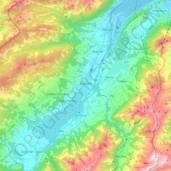
Nom : Carte topographique Sarnen, altitude, relief.
Lieu : Sarnen, Obwalden, Switzerland (46.85422 8.06700 46.93346 8.27766)
Altitude moyenne : 1.040 m
Altitude minimum : 428 m
Altitude maximum : 2.354 m
Sarnen is situated at an altitude of 471 m (1,545 ft) on the northern shore of Lake Sarnen (German: Sarnersee) along the outflow of the Sarner Aa. Lake Sarnen covers approximately an area of 7.5 km2 (2.9 sq mi). The town is surrounded by mountain chains and a protected bog can be found nearby. The most well-known mountain close to Sarnen is Mount Pilatus with an elevation of 2,132 m (6,995 ft).