
Carte topographique Isla Hoste
Carte interactive
Cliquez sur la carte pour afficher l’altitude.
À propos de cette carte
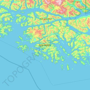
Nom : Carte topographique Isla Hoste, altitude, relief.
Altitude moyenne : 170 m
Altitude minimum : -4 m
Altitude maximum : 2.285 m
Autres cartes topographiques
Cliquez sur une carte pour visualiser sa topographie, son altitude et son relief.
Kap Hoorn
Chile > Region von Magellan und der chilenischen Antarktis > Provinz der chilenischen Antarktis > Kap Hoorn
Kap Hoorn, Provinz der chilenischen Antarktis, Region von Magellan und der chilenischen Antarktis, Chile
Altitude moyenne : 92 m
Punta Arenas
Chile > Region von Magellan und der chilenischen Antarktis > Provincia de Magallanes > Punta Arenas
Punta Arenas, Provincia de Magallanes, Region von Magellan und der chilenischen Antarktis, Chile
Altitude moyenne : 187 m
Natales
Chile > Region von Magellan und der chilenischen Antarktis > Provincia de Última Esperanza > Natales
Natales, Provincia de Última Esperanza, Region von Magellan und der chilenischen Antarktis, Chile
Altitude moyenne : 353 m
Isla Doble Pico
Chile > Region von Magellan und der chilenischen Antarktis > Natales
Isla Doble Pico, Natales, Provincia de Última Esperanza, Region von Magellan und der chilenischen Antarktis, Chile
Altitude moyenne : 15 m
Isla Aguirre
Chile > Region von Magellan und der chilenischen Antarktis > Kap Hoorn
Isla Aguirre, Kap Hoorn, Provinz der chilenischen Antarktis, Region von Magellan und der chilenischen Antarktis, Chile
Altitude moyenne : 67 m