
Carte topographique Hainault Forest
Cliquez sur la carte pour afficher l’altitude.
À propos de cette carte
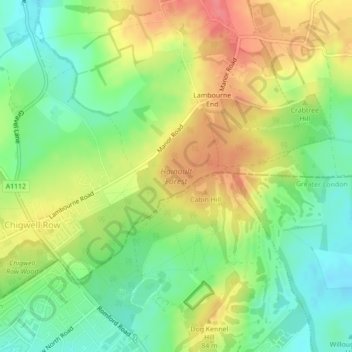
Nom : Carte topographique Hainault Forest, altitude, relief.
Altitude moyenne : 67 m
Altitude minimum : 35 m
Altitude maximum : 105 m
Autres cartes topographiques
Cliquez sur une carte pour visualiser sa topographie, son altitude et son relief.
Nazeing Gate
United Kingdom > England > Essex > Epping Forest > Bumble's Green > Nazeing
Altitude moyenne : 70 m
Roughtalley's Wood (South) & Epping Forest Woodland Burial Ground
United Kingdom > England > Essex > Epping Forest > Coopersale
Altitude moyenne : 96 m
Passingford Bridge
United Kingdom > England > Essex > Epping Forest > Stapleford Tawney
Altitude moyenne : 53 m
How Green
United Kingdom > England > Essex > Epping Forest > Stapleford Abbotts
Altitude moyenne : 63 m
Thornwood Common
United Kingdom > England > Essex > Epping Forest > Thornwood Common
Altitude moyenne : 89 m
Steward's Green
United Kingdom > England > Essex > Epping Forest > Coopersale Street > Steward's Green
Altitude moyenne : 76 m
Passingford Bridge
United Kingdom > England > Essex > Epping Forest > Stapleford Tawney
Altitude moyenne : 53 m