
Carte topographique Kaniyapuram
Carte interactive
Cliquez sur la carte pour afficher l’altitude.
À propos de cette carte
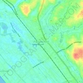
Nom : Carte topographique Kaniyapuram, altitude, relief.
Lieu : Kaniyapuram, Thiruvananthapuram, Kerala, 695301, India (8.56766 76.83607 8.60766 76.87607)
Altitude moyenne : 15 m
Altitude minimum : 0 m
Altitude maximum : 50 m
Autres cartes topographiques
Cliquez sur une carte pour visualiser sa topographie, son altitude et son relief.
Thiruvananthapuram
India > Kerala > Thiruvananthapuram
Thiruvananthapuram, Thiruvananthapuram District, Kerala, 695001, India
Altitude moyenne : 33 m
Kadinamkulam
India > Kerala > Thiruvananthapuram > Puthenthope
Kadinamkulam, Puthenthope, Thiruvananthapuram, Thiruvananthapuram District, Kerala, India
Altitude moyenne : 10 m
Kuravankonam
India > Kerala > Thiruvananthapuram > Thiruvananthapuram
Kuravankonam, Kowdiar, Thiruvananthapuram, Thiruvananthapuram District, Kerala, 695001, India
Altitude moyenne : 36 m
Kumizhi kulam
India > Kerala > Thiruvananthapuram > Thiruvananthapuram
Kumizhi kulam, Kazhakkoottam, Thiruvananthapuram, Kerala, 695001, India
Altitude moyenne : 25 m
Aakulam park
India > Kerala > Thiruvananthapuram > Thiruvananthapuram
Aakulam park, Paruthippara, Thiruvananthapuram, Kerala, 695001, India
Altitude moyenne : 37 m
Kovalam
India > Kerala > Thiruvananthapuram
Kovalam, Thiruvananthapuram, Kerala, 695527, India
Altitude moyenne : 24 m
Karamana River
India > Kerala > Thiruvananthapuram > Thiruvananthapuram
Karamana River, Thiruvananthapuram, Kerala, 695001, India
Altitude moyenne : 50 m
Mangalapuram
India > Kerala > Thiruvananthapuram
Mangalapuram, Thiruvananthapuram, Kerala, 695317, India
Altitude moyenne : 33 m
Mannanthala
India > Kerala > Thiruvananthapuram > Mannanthala
Mannanthala, Thiruvananthapuram, Kerala, 695003, India
Altitude moyenne : 51 m