
Carte topographique Village of Lake Placid
Carte interactive
Cliquez sur la carte pour afficher l’altitude.
À propos de cette carte
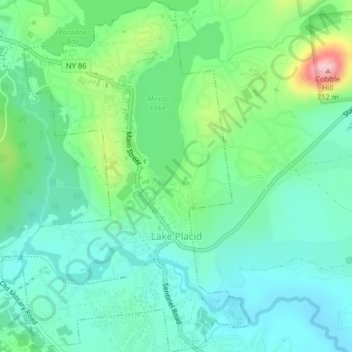
Nom : Carte topographique Village of Lake Placid, altitude, relief.
Altitude moyenne : 558 m
Altitude minimum : 507 m
Altitude maximum : 701 m
Lake Placid is well known among winter-sports enthusiasts for its skiing, both Alpine and Nordic. Whiteface Mountain (4,867 ft or 1,483 m), in nearby Wilmington about 13 miles (21 km) from Lake Placid, offers skiing, hiking, gondola rides, and mountain biking, and is the only one of the High Peaks that can be reached by an auto road. Whiteface Mountain has a vertical elevation of 3,430 feet (1,050 m), the highest vertical elevation of mountains in Eastern North America. The area has one of only 16 bobsled runs in the Western Hemisphere.
Autres cartes topographiques
Cliquez sur une carte pour visualiser sa topographie, son altitude et son relief.
Heart Lake
United States > New York > Essex County
Heart Lake, Town of North Elba, Essex County, New York, United States
Altitude moyenne : 690 m
Grover Hills
United States > New York > Essex County > Mineville
Grover Hills, Mineville, Town of Moriah, Essex County, New York, 12956, United States
Altitude moyenne : 315 m
Ray Brook
United States > New York > Essex County
Ray Brook, Town of North Elba, Essex County, New York, 12977, United States
Altitude moyenne : 526 m
Keene Valley
United States > New York > Essex County > Town of Keene
Keene Valley, Town of Keene, Essex County, New York, 12943, United States
Altitude moyenne : 459 m
Town of Lewis
United States > New York > Essex County
Town of Lewis, Essex County, New York, 12950, United States
Altitude moyenne : 352 m
Saint Huberts
United States > New York > Essex County > Town of Keene
Saint Huberts, Town of Keene, Essex County, New York, 12943, United States
Altitude moyenne : 536 m
Town of Saint Armand
United States > New York > Essex County
Town of Saint Armand, Essex County, New York, 12913, United States
Altitude moyenne : 577 m
Town of Elizabethtown
United States > New York > Essex County
Town of Elizabethtown, Essex County, New York, United States
Altitude moyenne : 406 m
Witherbee
United States > New York > Essex County > Town of Moriah
Witherbee, Town of Moriah, Essex County, New York, 12998, United States
Altitude moyenne : 376 m
Craterclub
United States > New York > Essex County
Craterclub, Town of Essex, Essex County, New York, 12936, United States
Altitude moyenne : 50 m
Deerhead
United States > New York > Essex County > Town of Lewis
Deerhead, Town of Lewis, Essex County, New York, United States
Altitude moyenne : 253 m
Port Douglass
United States > New York > Essex County
Port Douglass, Town of Chesterfield, Essex County, New York, 12975, United States
Altitude moyenne : 110 m
Town of Essex
United States > New York > Essex County
Town of Essex, Essex County, New York, 12936, United States
Altitude moyenne : 71 m
Port Kent
United States > New York > Essex County
Port Kent, Town of Chesterfield, Essex County, New York, 12975, United States
Altitude moyenne : 63 m
Boquet
United States > New York > Essex County
Boquet, Town of Essex, Essex County, New York, 12936, United States
Altitude moyenne : 112 m
Whallonsburg
United States > New York > Essex County
Whallonsburg, Town of Essex, Essex County, New York, 12936, United States
Altitude moyenne : 104 m
Green Street
United States > New York > Essex County > Town of Jay
Green Street, Town of Jay, Essex County, New York, United States
Altitude moyenne : 320 m
Stowersville
United States > New York > Essex County > Town of Lewis
Stowersville, Town of Lewis, Essex County, New York, 12950, United States
Altitude moyenne : 183 m
AuSable Chasm
United States > New York > Essex County
AuSable Chasm, Town of Chesterfield, Essex County, New York, 12911, United States
Altitude moyenne : 110 m
Burdick Crossing
United States > New York > Essex County > Town of Crown Point
Burdick Crossing, Town of Crown Point, Essex County, New York, 12928, United States
Altitude moyenne : 41 m
Cold Spring Park
United States > New York > Essex County > Town of Crown Point
Cold Spring Park, Town of Crown Point, Essex County, New York, 12928, United States
Altitude moyenne : 256 m
Crown Point Center
United States > New York > Essex County > Town of Crown Point
Crown Point Center, Town of Crown Point, Essex County, New York, 12928, United States
Altitude moyenne : 158 m
Factoryville
United States > New York > Essex County > Town of Crown Point
Factoryville, Town of Crown Point, Essex County, New York, 12928, United States
Altitude moyenne : 126 m
Ironville
United States > New York > Essex County > Town of Crown Point
Ironville, Town of Crown Point, Essex County, New York, United States
Altitude moyenne : 326 m
Glenmore
United States > New York > Essex County > Town of Keene
Glenmore, Town of Keene, Essex County, New York, 12942, United States
Altitude moyenne : 648 m
North Jay
United States > New York > Essex County > Town of Jay
North Jay, Town of Jay, Essex County, New York, United States
Altitude moyenne : 263 m
Rome
United States > New York > Essex County > Town of Jay
Rome, Town of Jay, Essex County, New York, 12912, United States
Altitude moyenne : 237 m
Crowningshield
United States > New York > Essex County > Town of Lewis
Crowningshield, Town of Lewis, Essex County, New York, United States
Altitude moyenne : 183 m
Aiden Lair
United States > New York > Essex County
Aiden Lair, Town of Minerva, Essex County, New York, United States
Altitude moyenne : 563 m
Boreas River
United States > New York > Essex County
Boreas River, Essex County, New York, United States
Altitude moyenne : 575 m
The Grove
United States > New York > Essex County > Town of Jay
The Grove, Town of Jay, Essex County, New York, United States
Altitude moyenne : 240 m
Town of Chesterfield
United States > New York > Essex County
Town of Chesterfield, Essex County, New York, United States
Altitude moyenne : 195 m
Bloomingdale
United States > New York > Essex County
Bloomingdale, Town of Saint Armand, Essex County, New York, 12913, United States
Altitude moyenne : 490 m
Town of Crown Point
United States > New York > Essex County
Town of Crown Point, Essex County, New York, 12928, United States
Altitude moyenne : 164 m
Giant Mountain
United States > New York > Essex County > Town of Keene
Giant Mountain, Town of Keene, Essex County, New York, United States
Altitude moyenne : 1.060 m
Town of Westport
United States > New York > Essex County
Town of Westport, Essex County, New York, 12993, United States
Altitude moyenne : 151 m
Bear Mountain
United States > New York > Essex County > Town of Ticonderoga
Bear Mountain, Town of Ticonderoga, Essex County, New York, 12883, United States
Altitude moyenne : 173 m
Upper Jay
United States > New York > Essex County > Town of Jay
Upper Jay, Town of Jay, Essex County, New York, 12987, United States
Altitude moyenne : 323 m
Paradox
United States > New York > Essex County
Paradox, Town of Schroon, Essex County, New York, 12858, United States
Altitude moyenne : 322 m
Town of North Elba
United States > New York > Essex County
Town of North Elba, Essex County, New York, United States
Altitude moyenne : 728 m
Whiteface Mountain
United States > New York > Essex County > Town of Wilmington
Whiteface Mountain, Town of Wilmington, Essex County, New York, United States
Altitude moyenne : 1.090 m
Whiteface
United States > New York > Essex County
Whiteface, Town of North Elba, Essex County, New York, 12946, United States
Altitude moyenne : 636 m
Town of North Hudson
United States > New York > Essex County
Town of North Hudson, Essex County, New York, 12855, United States
Altitude moyenne : 539 m
Blue Ridge Mountain
United States > New York > Essex County > Town of North Hudson
Blue Ridge Mountain, Town of North Hudson, Essex County, New York, United States
Altitude moyenne : 818 m
Olmstedville
United States > New York > Essex County
Olmstedville, Town of Minerva, Essex County, New York, 12857, United States
Altitude moyenne : 379 m
Keeseville
United States > New York > Essex County
Keeseville, Town of Chesterfield, Essex County, New York, 12944, United States
Altitude moyenne : 150 m
Schroon Lake
United States > New York > Essex County > Schroon Lake
Schroon Lake, Essex County, New York, 12870, United States
Altitude moyenne : 290 m
Town of Moriah
United States > New York > Essex County
Town of Moriah, Essex County, New York, United States
Altitude moyenne : 283 m
Town of Newcomb
United States > New York > Essex County
Town of Newcomb, Essex County, New York, 12852, United States
Altitude moyenne : 627 m
Town of Minerva
United States > New York > Essex County
Town of Minerva, Essex County, New York, United States
Altitude moyenne : 528 m