
Carte topographique Conshohocken Station
Carte interactive
Cliquez sur la carte pour afficher l’altitude.
À propos de cette carte
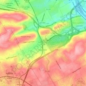
Nom : Carte topographique Conshohocken Station, altitude, relief.
Altitude moyenne : 98 m
Altitude minimum : 13 m
Altitude maximum : 156 m
Autres cartes topographiques
Cliquez sur une carte pour visualiser sa topographie, son altitude et son relief.
Hidden Valley
United States > Pennsylvania > Montgomery County > Upper Merion Township > King of Prussia
Hidden Valley, King of Prussia, Upper Merion Township, Montgomery County, Pennsylvania, 19406, United States
Altitude moyenne : 47 m
Lafayette Park
United States > Pennsylvania > Montgomery County > Upper Merion Township > King of Prussia
Lafayette Park, King of Prussia, Upper Merion Township, Montgomery County, Pennsylvania, 19406, United States
Altitude moyenne : 54 m
Bob White Farms
United States > Pennsylvania > Montgomery County > Upper Merion Township
Bob White Farms, Upper Merion Township, Montgomery County, Pennsylvania, 19097, United States
Altitude moyenne : 95 m
King of Prussia
United States > Pennsylvania > Montgomery County > Upper Merion Township
King of Prussia, Upper Merion Township, Montgomery County, Pennsylvania, 19406, United States
Altitude moyenne : 59 m