
Faire un don
Équipez-vous pour votre prochaine aventure :
En tant que Partenaire Amazon, ce site perçoit une commission sur les achats éligibles sans surcoût pour vous.
Carte topographique Kangju Kangri
Cliquez sur la carte pour afficher l’altitude.
Faire un don
Équipez-vous pour votre prochaine aventure :
En tant que Partenaire Amazon, ce site perçoit une commission sur les achats éligibles sans surcoût pour vous.
Kangju Kangri
Kangju Kangri is a mountain in the Karakoram Range of Asia located in the union territory of Ladakh, India. With a summit elevation of 6,725 meters above sea level, it is the highest peak of the Pangong range, a subrange of the Karakoram. Kangju Kangri rises over the winding, tri-headed Kangju glacier and Pangong Lake to the east.
Faire un don
Équipez-vous pour votre prochaine aventure :
En tant que Partenaire Amazon, ce site perçoit une commission sur les achats éligibles sans surcoût pour vous.
À propos de cette carte
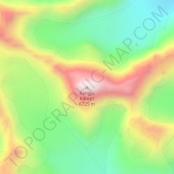
Nom : Carte topographique Kangju Kangri, altitude, relief.
Lieu : Kangju Kangri, Leh Tehsil, Leh district, Ladakh, India (33.72521 78.52739 33.72531 78.52749)
Altitude moyenne : 6.190 m
Altitude minimum : 5.820 m
Altitude maximum : 6.694 m
Faire un don
Équipez-vous pour votre prochaine aventure :
En tant que Partenaire Amazon, ce site perçoit une commission sur les achats éligibles sans surcoût pour vous.
Autres cartes topographiques
Cliquez sur une carte pour visualiser sa topographie, son altitude et son relief.
Indus
India > Ladakh > Leh Tehsil
In the uppermost, highest part of the Indus River basin there are relatively few genera and species: Diptychus, Ptychobarbus, Schizopyge, Schizopygopsis and Schizothorax snowtrout, Triplophysa loaches, and the catfish Glyptosternon reticulatum. Going downstream these are soon joined by the golden mahseer Tor…
Altitude moyenne : 4.192 m