
Faire un don
Équipez-vous pour votre prochaine aventure :
En tant que Partenaire Amazon, ce site perçoit une commission sur les achats éligibles sans surcoût pour vous.
Carte topographique Ferreries
Cliquez sur la carte pour afficher l’altitude.
Faire un don
Équipez-vous pour votre prochaine aventure :
En tant que Partenaire Amazon, ce site perçoit une commission sur les achats éligibles sans surcoût pour vous.
Ferreries
Ferreries is a municipality on the island of Menorca, in the Spanish autonomous community of the Balearic Islands. Its name is derived from the Catalan word ferrer ("blacksmith"), which in turn, comes from Latin word ferrum. At an elevation of 150 metres it is the island's highest town. Plaça Espanya
Faire un don
Équipez-vous pour votre prochaine aventure :
En tant que Partenaire Amazon, ce site perçoit une commission sur les achats éligibles sans surcoût pour vous.
À propos de cette carte
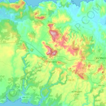
Nom : Carte topographique Ferreries, altitude, relief.
Lieu : Ferreries, Menorca, Balearic Islands, 07750, Spain (39.92902 3.95743 40.05963 4.06378)
Altitude moyenne : 82 m
Altitude minimum : 0 m
Altitude maximum : 268 m
Faire un don
Équipez-vous pour votre prochaine aventure :
En tant que Partenaire Amazon, ce site perçoit une commission sur les achats éligibles sans surcoût pour vous.