
Carte topographique Padum
Carte interactive
Cliquez sur la carte pour afficher l’altitude.
À propos de cette carte
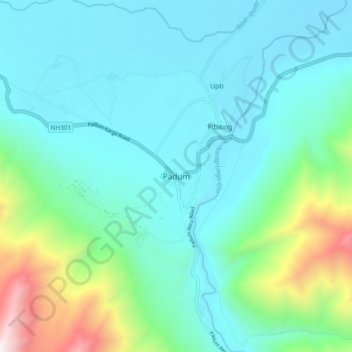
Nom : Carte topographique Padum, altitude, relief.
Lieu : Padum, Zanskar, Kargil District, Ladakh, 194302, India (33.44914 76.85818 33.48914 76.89818)
Altitude moyenne : 3.632 m
Altitude minimum : 3.507 m
Altitude maximum : 4.198 m
Padum is at the centre of the tri armed Zanskar valley. It has an average elevation of 3,657 metres (11,998 feet). There are several villages to the north-east of Padum leading to Karsha monastery.