
Faire un don
Équipez-vous pour votre prochaine aventure :
En tant que Partenaire Amazon, ce site perçoit une commission sur les achats éligibles sans surcoût pour vous.
Carte topographique Nafpaktos
Cliquez sur la carte pour afficher l’altitude.
Faire un don
Équipez-vous pour votre prochaine aventure :
En tant que Partenaire Amazon, ce site perçoit une commission sur les achats éligibles sans surcoût pour vous.
Nafpaktos
Today the population is about 19,768 people according to the 2011 census. Residential homes align with the Gulf of Corinth over a length of about 3 km (2 mi) and a width of about 1 km (0.6 mi). The port divides the beachfront in two parts. The Western part is called Psani, while the Eastern part Gribovo. Naupactus sits on a shoulder of a mountain range on the north while farmlands dominate the western part. It used to be on the GR-48/E65 linking Antirrio and Amfissa; now it is bypassed to the north at the elevation of 150 to 200 m (492 to 656 ft) above sea level. The bypass has contributed significantly in lowering the number of heavy trucks passing through the narrow streets of the town.
Faire un don
Équipez-vous pour votre prochaine aventure :
En tant que Partenaire Amazon, ce site perçoit une commission sur les achats éligibles sans surcoût pour vous.
À propos de cette carte
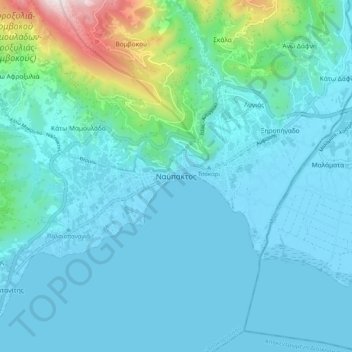
Nom : Carte topographique Nafpaktos, altitude, relief.
Altitude moyenne : 130 m
Altitude minimum : -6 m
Altitude maximum : 967 m
Faire un don
Équipez-vous pour votre prochaine aventure :
En tant que Partenaire Amazon, ce site perçoit une commission sur les achats éligibles sans surcoût pour vous.