
Faire un don
Équipez-vous pour votre prochaine aventure :
En tant que Partenaire Amazon, ce site perçoit une commission sur les achats éligibles sans surcoût pour vous.
Carte topographique Dharashiv
Cliquez sur la carte pour afficher l’altitude.
Faire un don
Équipez-vous pour votre prochaine aventure :
En tant que Partenaire Amazon, ce site perçoit une commission sur les achats éligibles sans surcoût pour vous.
Dharashiv
The city of Osmanabad has an elevation of 653 metres (2,142 ft). Osmanabad is located in the west-central part of Osmanabad Tahsil. Nearby towns include Tuljapur, Bhoom, Paranda, Washi, and Kalamb. Solapur, located southwest of Osmanabad in Solapur district, is the nearest sizeable city. Osmanabad is on the Balaghat Pathar. The Bhogavati River flows through the city and meets the Sina River near Mohol in the Solapur district.
Faire un don
Équipez-vous pour votre prochaine aventure :
En tant que Partenaire Amazon, ce site perçoit une commission sur les achats éligibles sans surcoût pour vous.
À propos de cette carte
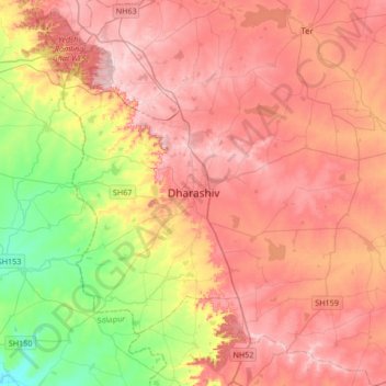
Nom : Carte topographique Dharashiv, altitude, relief.
Lieu : Dharashiv, Dharashiv District, Maharashtra, 413500, India (18.02536 75.88203 18.34536 76.20203)
Altitude moyenne : 619 m
Altitude minimum : 487 m
Altitude maximum : 719 m
Faire un don
Équipez-vous pour votre prochaine aventure :
En tant que Partenaire Amazon, ce site perçoit une commission sur les achats éligibles sans surcoût pour vous.