Géolocaliser
👉 Easily get elevation data in JSON, GeoTIFF and KML formats using Elevation API
Merci de soutenir ce site ❤️
Faire un don

Équipez-vous pour votre prochaine aventure :

En tant que Partenaire Amazon, ce site perçoit une commission sur les achats éligibles sans surcoût pour vous.

Carte topographique Chart Sutton

Cliquez sur la carte pour afficher l’altitude.

À propos de cette carte

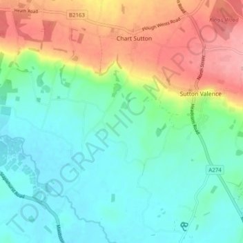
Nom : Carte topographique Chart Sutton, altitude, relief.

Lieu : Chart Sutton, Maidstone, Kent, England, United Kingdom (51.18299 0.54950 51.23116 0.58706)

Altitude moyenne : 54 m

Altitude minimum : 13 m

Altitude maximum : 135 m

👉 Easily get elevation data in JSON, GeoTIFF and KML formats using Elevation API
Merci de soutenir ce site ❤️
Faire un don

Équipez-vous pour votre prochaine aventure :

En tant que Partenaire Amazon, ce site perçoit une commission sur les achats éligibles sans surcoût pour vous.

Autres cartes topographiques

Cliquez sur une carte pour visualiser sa topographie, son altitude et son relief.

Westfield Sole

United Kingdom > England > Kent > Maidstone

Altitude moyenne : 145 m

Detling Hill

United Kingdom > England > Kent > Maidstone

Altitude moyenne : 152 m

Mote Park

United Kingdom > England > Kent > Maidstone > Otham

Altitude moyenne : 52 m

Broomfield

United Kingdom > England > Kent > Maidstone > Leeds

Altitude moyenne : 96 m

Lenham Heath

United Kingdom > England > Kent > Maidstone

Altitude moyenne : 96 m

Leadingcross Green

United Kingdom > England > Kent > Maidstone > Lenham

Altitude moyenne : 118 m

Walderslade Woods

United Kingdom > England > Kent > Maidstone

Altitude moyenne : 155 m

Harpole

United Kingdom > England > Kent > Maidstone > Detling

Altitude moyenne : 103 m

Bletchenden

United Kingdom > England > Kent > Maidstone > Headcorn

Altitude moyenne : 24 m

Liverton Street

United Kingdom > England > Kent > Maidstone > Grafty Green

Altitude moyenne : 102 m

Linton

United Kingdom > England > Kent > Maidstone

Altitude moyenne : 71 m

East Lenham

United Kingdom > England > Kent > Maidstone > Lenham

Altitude moyenne : 127 m

Bicknor Wood

United Kingdom > England > Kent > Maidstone > Otham

Altitude moyenne : 85 m

Laddingford

United Kingdom > England > Kent > Maidstone > Yalding

Altitude moyenne : 14 m

Langley Park

United Kingdom > England > Kent > Maidstone > Langley

Altitude moyenne : 96 m

Bletchingly

United Kingdom > England > Kent > Maidstone

Altitude moyenne : 37 m

Weavering Park

United Kingdom > England > Kent > Maidstone > Grove Green

Altitude moyenne : 56 m

Eyhorne Street

United Kingdom > England > Kent > Maidstone > Hollingbourne

Altitude moyenne : 90 m

Kingswood

United Kingdom > England > Kent > Maidstone

Altitude moyenne : 109 m

Équipez-vous pour votre prochaine aventure :

🛠️Outils Multifonctions - Le couteau suisse indispensable à l'explorateur
📱Supports Smartphone Vélo - Utilisez topographic-map.com en direct sur votre guidon
🥾Chaussures de trekking - Chaussures adaptées aux longues distances et aux terrains techniques
🧥Vestes imperméables - Vestes coupe-vent et pluie pour outdoor
🧽Serviettes microfibre - Séchage rapide en voyage

En tant que Partenaire Amazon, ce site perçoit une commission sur les achats éligibles sans surcoût pour vous.