
Carte topographique Drang Drung Glacier
Carte interactive
Cliquez sur la carte pour afficher l’altitude.
À propos de cette carte
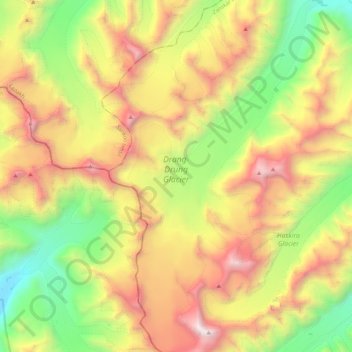
Nom : Carte topographique Drang Drung Glacier, altitude, relief.
Altitude moyenne : 5.098 m
Altitude minimum : 3.938 m
Altitude maximum : 6.533 m
The Drang-Drung Glacier is likely to be the largest glacier in Ladakh after the Siachen Glacier in the Karakoram Range, with a maximum length of 23 km (14 mi) at an average elevation of 4,780 m (15,680 ft; 2.97 mi). The glacier lies in the northeastern Himalayan Range known as the Zanskar Range, 142 km (88 mi) south of Kargil and 331 km (206 mi) east of Srinagar, the capital of Jammu and Kashmir.