
Carte topographique Cherwell District
Carte interactive
Cliquez sur la carte pour afficher l’altitude.
À propos de cette carte
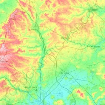
Nom : Carte topographique Cherwell District, altitude, relief.
Lieu : Cherwell District, Oxfordshire, England, United Kingdom (51.78096 -1.52284 52.16847 -1.04714)
Altitude moyenne : 116 m
Altitude minimum : 56 m
Altitude maximum : 240 m
Autres cartes topographiques
Cliquez sur une carte pour visualiser sa topographie, son altitude et son relief.
Hornton
United Kingdom > England > Oxfordshire > Cherwell District
Hornton, Cherwell District, Oxfordshire, England, United Kingdom
Altitude moyenne : 172 m
Abingdon
United Kingdom > England > Oxfordshire > Vale of White Horse
Abingdon, Vale of White Horse, Oxfordshire, England, OX14 3UJ, United Kingdom
Altitude moyenne : 64 m
Juniper Hill
United Kingdom > England > Oxfordshire > Cherwell District > Cottisford
Juniper Hill, Cottisford, Cherwell District, Oxfordshire, England, NN13 5RN, United Kingdom
Altitude moyenne : 126 m
Wheatley
United Kingdom > England > Oxfordshire > South Oxfordshire
Wheatley, South Oxfordshire, Oxfordshire, England, United Kingdom
Altitude moyenne : 90 m
Bletchingdon
United Kingdom > England > Oxfordshire > Cherwell District
Bletchingdon, Cherwell District, Oxfordshire, England, United Kingdom
Altitude moyenne : 76 m
Roke
United Kingdom > England > Oxfordshire > South Oxfordshire > Berrick Salome
Roke, Berrick Salome, South Oxfordshire, Oxfordshire, England, OX10 6JE, United Kingdom
Altitude moyenne : 69 m
Bicester
United Kingdom > England > Oxfordshire > Cherwell District
Bicester, Cherwell District, Oxfordshire, England, United Kingdom
Altitude moyenne : 76 m
Burford
United Kingdom > England > Oxfordshire > West Oxfordshire > Fulbrook
Burford, Fulbrook, West Oxfordshire, Oxfordshire, England, United Kingdom
Altitude moyenne : 129 m
Thame
United Kingdom > England > Oxfordshire > South Oxfordshire
Thame, South Oxfordshire, Oxfordshire, England, United Kingdom
Altitude moyenne : 74 m
Duns Tew
United Kingdom > England > Oxfordshire > Cherwell District
Duns Tew, Cherwell District, Oxfordshire, England, United Kingdom
Altitude moyenne : 125 m
Wantage
United Kingdom > England > Oxfordshire > Vale of White Horse
Wantage, Vale of White Horse, Oxfordshire, England, United Kingdom
Altitude moyenne : 151 m
Oxford
United Kingdom > England > Oxfordshire > Oxford
Oxford, Oxfordshire, South East England, England, OX1 3HY, United Kingdom
Altitude moyenne : 81 m
Banbury
United Kingdom > England > Oxfordshire > Cherwell District
Banbury, Cherwell District, Oxfordshire, England, United Kingdom
Altitude moyenne : 116 m
East Hendred
United Kingdom > England > Oxfordshire > Vale of White Horse
East Hendred, Vale of White Horse, Oxfordshire, England, United Kingdom
Altitude moyenne : 119 m