
Carte topographique Catharinau
Carte interactive
Cliquez sur la carte pour afficher l’altitude.
À propos de cette carte
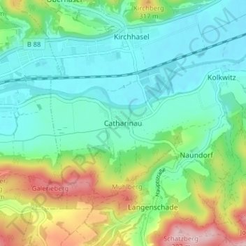
Nom : Carte topographique Catharinau, altitude, relief.
Altitude moyenne : 240 m
Altitude minimum : 179 m
Altitude maximum : 389 m
Autres cartes topographiques
Cliquez sur une carte pour visualiser sa topographie, son altitude et son relief.
Am Luisenturm
Deutschland > Thüringen > Landkreis Saalfeld-Rudolstadt > Uhlstädt-Kirchhasel > Kleinkochberg
Am Luisenturm, Kleinkochberg, Uhlstädt-Kirchhasel, Landkreis Saalfeld-Rudolstadt, Thüringen, Deutschland
Altitude moyenne : 448 m
Dorndorf
Deutschland > Thüringen > Landkreis Saalfeld-Rudolstadt > Uhlstädt-Kirchhasel > Dorndorf
Dorndorf, Uhlstädt-Kirchhasel, Landkreis Saalfeld-Rudolstadt, Thüringen, Deutschland
Altitude moyenne : 331 m