
Carte topographique Highwood
Carte interactive
Cliquez sur la carte pour afficher l’altitude.
À propos de cette carte
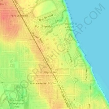
Nom : Carte topographique Highwood, altitude, relief.
Lieu : Highwood, Lake County, Illinois, 60040, United States (42.19608 -87.82154 42.21779 -87.80441)
Altitude moyenne : 198 m
Altitude minimum : 174 m
Altitude maximum : 220 m
Highwood is located in southeastern Lake County at 42°12′19″N 87°48′44″W / 42.205357°N 87.812345°W / 42.205357; -87.812345, on a ridge 100 feet (30 m) above the elevation of Lake Michigan.
Autres cartes topographiques
Cliquez sur une carte pour visualiser sa topographie, son altitude et son relief.
Fox Lake Hills
United States > Illinois > Lake County
Fox Lake Hills, Lake County, Illinois, United States
Altitude moyenne : 232 m
Vernon Hills
United States > Illinois > Lake County
Vernon Hills, Lake County, Illinois, 60061, United States
Altitude moyenne : 219 m
Highland Park
United States > Illinois > Lake County > Highland Park
Highland Park, Lake County, Illinois, 60035, United States
Altitude moyenne : 194 m
Round Lake Beach
United States > Illinois > Lake County
Round Lake Beach, Lake County, Illinois, 60073, United States
Altitude moyenne : 240 m
Third Lake
United States > Illinois > Lake County
Third Lake, Lake County, Illinois, United States
Altitude moyenne : 236 m
Gurnee
United States > Illinois > Lake County
Gurnee, Lake County, Illinois, United States
Altitude moyenne : 213 m
Hastings Lake
United States > Illinois > Lake County
Hastings Lake, Lake County, Illinois, United States
Altitude moyenne : 240 m
Great Lakes
United States > Illinois > Lake County > North Chicago
Great Lakes, North Chicago, Lake County, Illinois, 60088, United States
Altitude moyenne : 201 m
Lake Catherine
United States > Illinois > Lake County > Lake Catherine
Lake Catherine, Lake County, Illinois, United States
Altitude moyenne : 229 m
Lake Barrington
United States > Illinois > Lake County > Lake Barrington
Lake Barrington, Lake County, Illinois, United States
Altitude moyenne : 241 m
Little Bear Lake
United States > Illinois > Lake County > Vernon Hills
Little Bear Lake, Vernon Hills, Lake County, Illinois, United States
Altitude moyenne : 214 m
Third Lake
United States > Illinois > Lake County > Third Lake
Third Lake, Lake County, Illinois, 60046:60048, United States
Altitude moyenne : 236 m
Waukegan
United States > Illinois > Lake County > Waukegan
Waukegan, Lake County, Illinois, 60085, United States
Altitude moyenne : 200 m
Lake Bluff
United States > Illinois > Lake County
Lake Bluff, Lake County, Illinois, 60044, United States
Altitude moyenne : 193 m
Sullivan Lake
United States > Illinois > Lake County > Lakemoor
Sullivan Lake, Lakemoor, Lake County, Illinois, United States
Altitude moyenne : 233 m
Lake Forest
United States > Illinois > Lake County > Lake Forest
Lake Forest, Lake County, Illinois, 60045, United States
Altitude moyenne : 199 m
Bannockburn
United States > Illinois > Lake County
Bannockburn, Lake County, Illinois, United States
Altitude moyenne : 206 m
Zion
United States > Illinois > Lake County
Zion, Lake County, Illinois, 60099, United States
Altitude moyenne : 198 m