
Carte topographique Navi Mumbai
Carte interactive
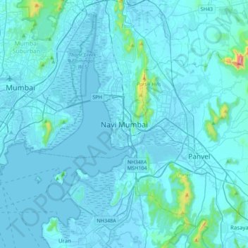
Cliquez sur la carte pour afficher l’altitude.
À propos de cette carte
Nom : Carte topographique Navi Mumbai, altitude, relief.
Altitude moyenne : 30 m
Altitude minimum : -4 m
Altitude maximum : 725 m
Navi Mumbai (Marathi pronunciation: , also known by its former name New Bombay), is a planned city off the west coast of the Indian state of Maharashtra in Konkan division. The city is divided into two parts, North Navi Mumbai and South Navi Mumbai, for the individual development of Panvel Mega City, which includes the area from Kharghar to Uran. Navi Mumbai has a population of 1,119,477 as per the 2011 provisional census. It has average city elevation excluding forest area of 14 meters.
Autres cartes topographiques
Cliquez sur une carte pour visualiser sa topographie, son altitude et son relief.
Bonkode Pond
India > Maharashtra > Thane > Navi Mumbai
Bonkode Pond, Kopar Khairne, Navi Mumbai, Thane, Thane District, Maharashtra, India
Altitude moyenne : 11 m